Multiservice Procedures for Well-Drilling Operations by Department of the Army, Navy and the Air Force - HTML preview
Download the book in PDF, ePub, Kindle for a complete version.


FM 5-484/NAVFAC P-1065/AFMAN 32-1072
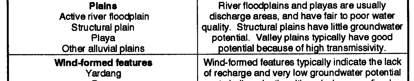
(12) Elevation and Relief. Elevation and relief provide an idea of the amount of groundwater replenishment within a drainage basin and its groundwater potential. In a region of about the same latitude, precipitation distribution is related to the elevation of the area with zones of higher elevation receiving more precipitation than lower areas. A small drainage basin at a high elevation may receive appreciably more recharge from precipitation than a much larger basin at a lower elevation.
Relief also has some effect on groundwater recharge. Areas with high relief (valleys bounded by prominent mountain ranges) have well-defined and easily identifiable recharge areas. In broad plains or plateaus, the moderate relief does not indicate recharge areas, and other indicators (grain size or drainage density) must be used.
(13) Drainage Pattern and Density. Recognizing drainage patterns can help define rock types, recharge areas and potential, and general hydrologic conditions of an area. Without geologic maps or other information on rock types, classification of the drainage pattern and landforms can provide an accurate interpretation of rock types and recognition of the area’s structure. Because most groundwater recharge occurs as infiltration of surface-water drainages, areas with high drainage densities receive more recharge than areas with low drainage densities. Recognizing drainage patterns and density can provide indications of the type of aquifers the magnitude of recharge in
an area, and directions of groundwater flow. Figure 2-27 (page 2-26) shows some of the more
common drainage patterns. Rock has widely spaced rectangular or dendritic patterns and alluvium has medium to widely spaced parallel drainage patterns along alluvial fans and dendritic patterns along valley ares and floodplains.
2-25
FM 5-484/NAVFAC P-1065/AFMAN 32-1072
b. Boundary Indicators. These are characteristics that are indicative of local or regional groundwater flow systems. By identifying the boundaries of flow systems, it is possible to define directions of groundwater flow and to estimate the depth and quality of groundwater within an area.
Boundary indicators do not directly indicate the presence of groundwater in an area.
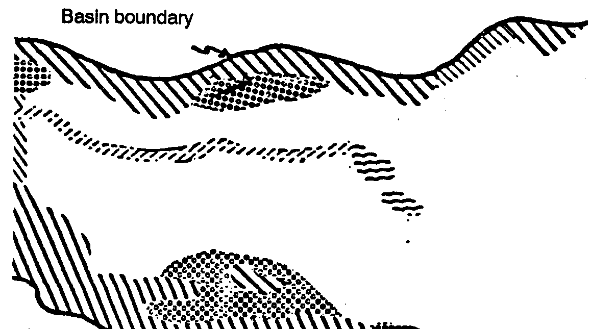
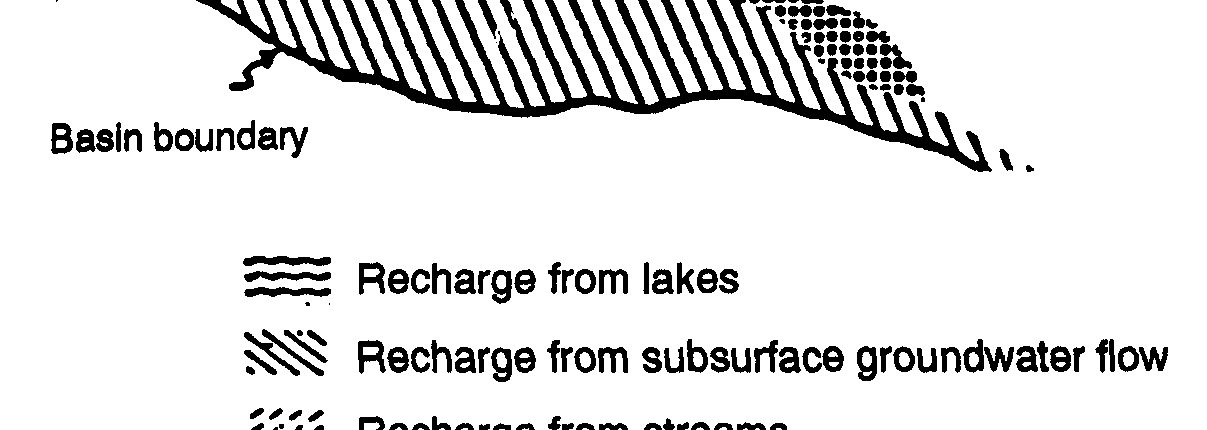
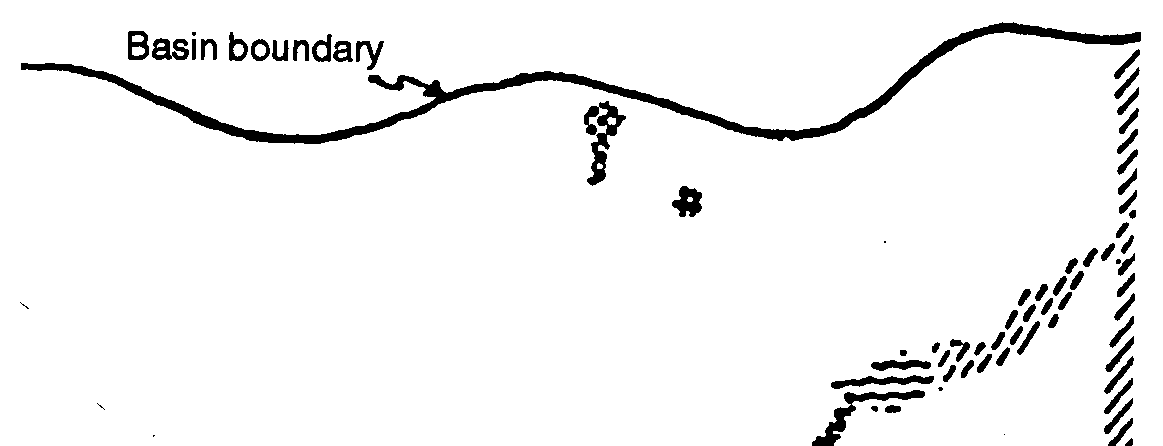
(1) Recharge Areas. These are areas where the groundwater reservoir is replenished. Recharge may be derived from the runoff of precipitation into rock fractures in mountainous areas, leakage
along streambeds or under lakes, or the flow of groundwater from upgradient areas. Figure 2-28
shows a sketch map of a hydragraphic basin with identified recharge areas. Some recharge occurs in mountain areas as direct infiltration. The precipitation that does not infiltrate runs off into the local drainage network. Some recharge occurs along the streambeds and the remaining runoff discharges on the alluvial fans where it infiltrates. Precipitation over the valley floor is channeled, and quantities of recharge occur along the valley drainage system. Various amounts of recharge are derived from lakes, ponds, or channels that may occur within the basin.
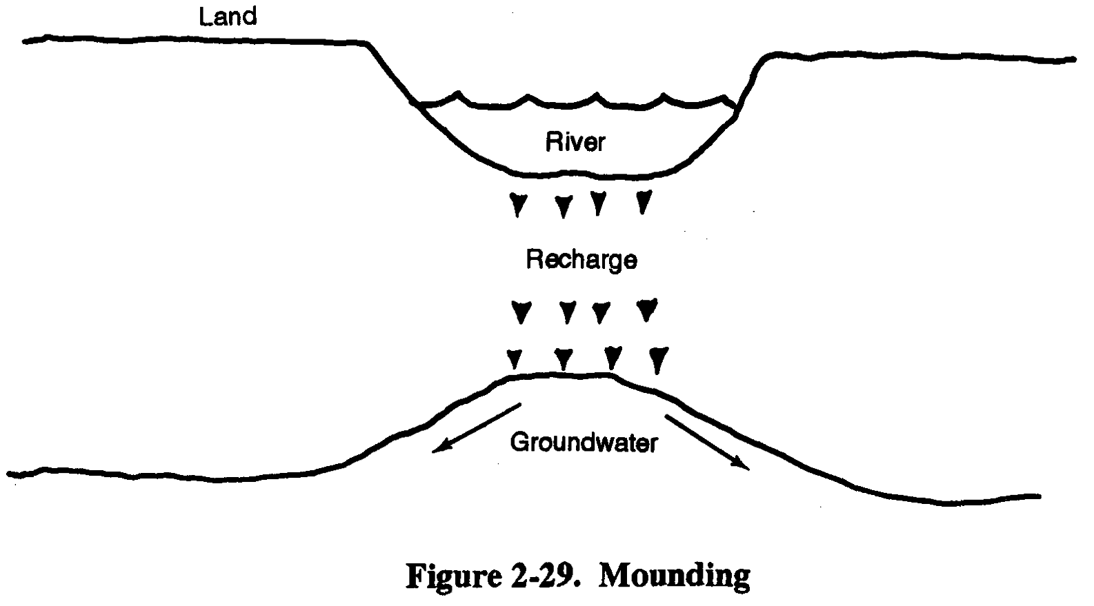
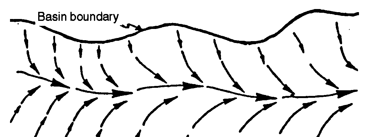
The recharge of groundwater from surface water sources usually results in a mound (bulge) in
the surface of the groundwater (Figure 2-29). Groundwater in such areas flows away from the
recharge sources. If the source is a lake, flow is radial away from the source. If the source is a linear source (mountain range or a stream), the groundwater divides and flow is primarily in two directions from the source. Areas recharged by direct infiltration or precipitation usually contain 2-26
FM 5-484/NAVFAC P-1065/AFMAN 32-1072
good quality groundwater.
Groundwater under lakes may exhibit
poor water quality because
evaporation of lake water may
increase the concentration of
chemicals in the lake and any recharge
derived from the lake. Groundwater
recharged from streams is usually
intermediate quality between
groundwater
recharged by
precipitation and lakes.
Subsurface recharge from
adjacent basins is often difficult to
assess. By knowing the elevation of
groundwater in adjacent areas, the
transmissivity of the aquifer, and the
width of the recharge area, it is
possible to estimate the amount of
recharge from subsurface flow. This
estimate usually is not possible in
areas with limited data. It is possible
to infer that such flow is occurring on
the basis of differences in elevation
and the location of barriers or conduits
between hydrographic basins.
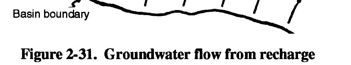
(2) Discharge Areas. Recharge to and discharge from a hydrographic basin must be equal.
Figure 2-30 (page 2-28) shows a sketch map of a hydrographic basin with identified discharge areas.
Figure 2-31 (page 2-28) shows the directions of groundwater flow from the recharge to the discharge
2-27


FM 5-484/NAVFAC P-1065/AFMAN 32-1072
areas. groundwater discharge can
occur in streams and lakes through
consumption by plants or man and
by subsurface flow to adjacent down
gradient basins.
The location of discharge areas
can help identify areas of shallow
groundwater. Streams sustained by
groundwater seepage, wetlands, and
certain types of vegetation indicate
discharge areas where groundwater
is close to land surface. Some types
of vegetation are capable of sending
tap roots to depths of over 100 feet
and are not indicative of shallow
groundwater.
The location of
subsurface discharge areas requires
more detailed knowledge of the
hydrologic balance of the area.
(3)
Impermeable and
Semipermeable Barriers. The
quantity and rate of groundwater
flow from recharge areas to
discharge areas are controlled by the
transmissivity of the aquifers.
Impermeable barriers are those
features (solid rock masses) through
which groundwater cannot flow.
Semipermeable barriers are those
features (faults or fractured rock
masses) that restrict flow but do not
act as a complete barrier. Such
features should be recognized
because they usually form the
boundaries of groundwater flow
systems and, when located within a
flow system, can result in areas of
shallow groundwater.
(4) Surface-Water Divides. Surface-water divides can form boundaries between groundwater flow systems. The mounding of groundwater under areas that receive recharge from the infiltration of precipitation causes groundwater to flow away from the recharge area. Similarly, surface water flows away from topographic highs that often correlate with groundwater recharge areas so that surface-water flow patterns usually coincide with groundwater flow patterns. The identification of surface-water divides can help define groundwater flow systems.
2-28
FM 5-484/NAVFAC P-1065/AFMAN 32-1072
c. Surface Indicators. Surface indicators are those features that suggest the presence of groundwater. These indicators can provide information about the depth, quantity, and quality of the groundwater resoures in an area; however, they do not positively indicate the presence of groundwater. The resource potential of an area is an inference on the basis of the presence (or absence) of certain indicators and particularly the association of these indicators.
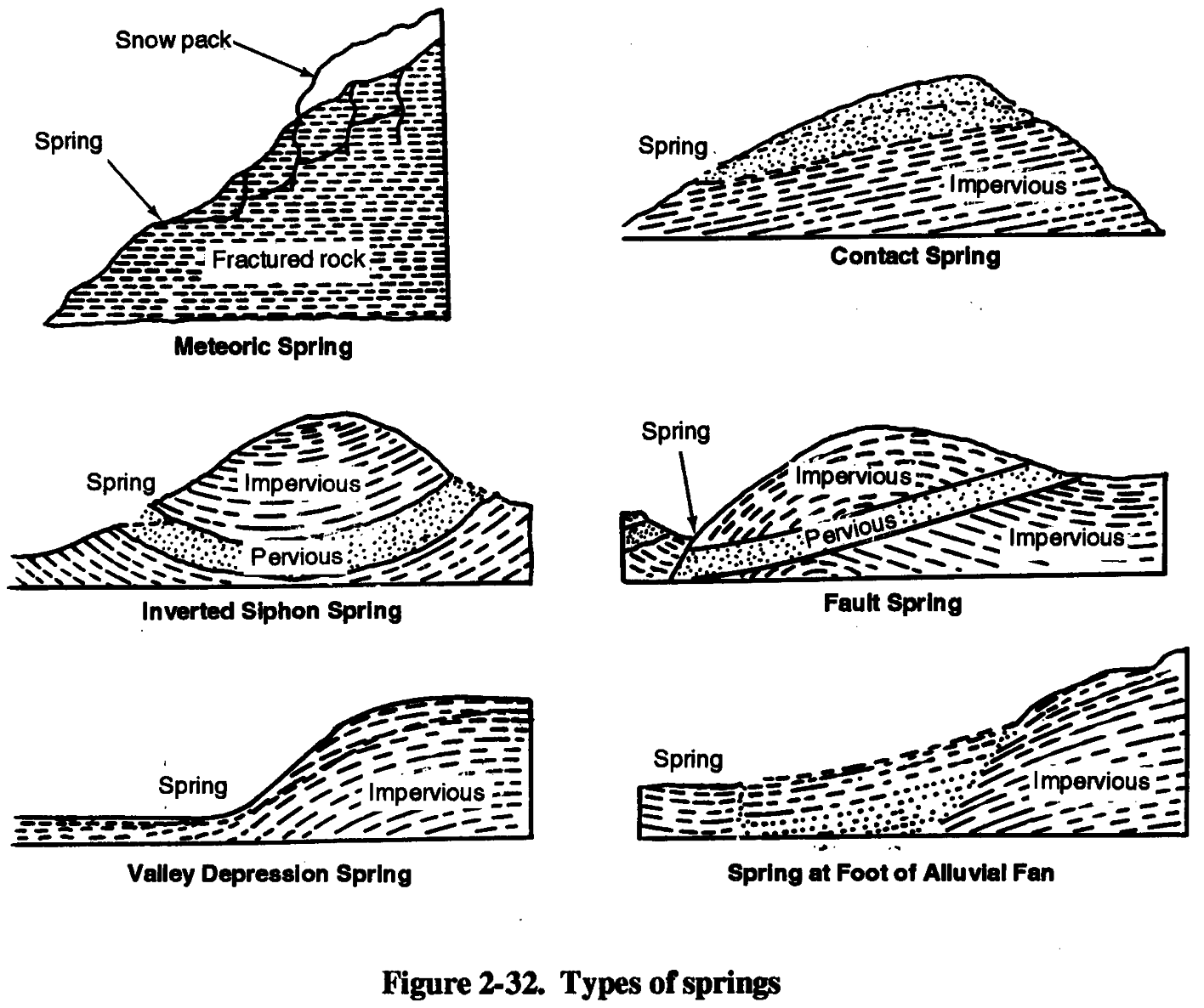
(1) Springs. Springs are effluences of groundwater occurring where the water table intercepts the ground surface. Springs are usually good indicators of the presence of shallow groundwater occurrences. However, the presence of shallow groundwater may not be indicative of a good area for well construction. Springs occur where groundwater discharges to the earth’s surface. Figure 2-32 shows several types of springs. Faults, valley-depressions, and alluvial-fan springs may discharge appreciable quantities of groundwater.
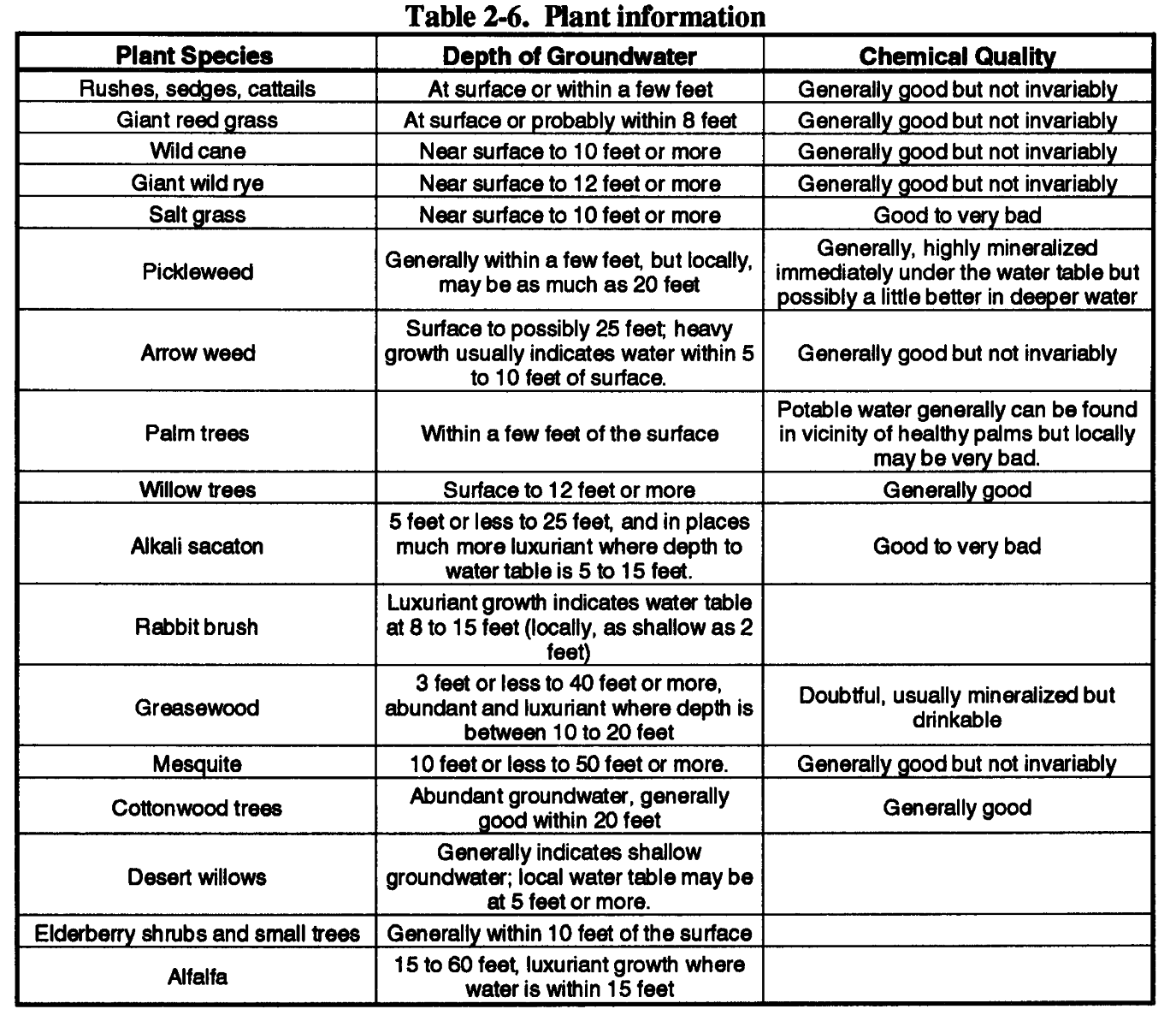
(2) Vegetation Type. Certain types of vegetation (or vegetative assemblages) are associated with specific hydrogeologic environments. Some plants (phreatophytes) can only exist if their root systems are in direct contact with groundwater. Phreatophytes, such as mesquite tress, have tap roots that go down more than 100 feet. Shrubs, such as saltbush, have roots that descend only a
few feet, making them excellent indicators of shallow groundwater. Table 2-6 (page 2-30) lists
several plants that indicate the presence of shallow groundwater. The density of vegetation can help 2-29
FM 5-484/NAVFAC P-1065/AFMAN 32-1072
define the location of recharge and discharge areas. Dense stands of vegetation along stream channels are riparian vegetation. Riparian vegetation along streams that discharge mountainous watersheds indicates that surface water is infiltrating the streambed and recharging the groundwater.
In many cases, the vegetation will decrease in density after the stream reaches the valley floor.
Somewhere along the sterambed, the riparian vegetation assemblage will give way to the typical valley-floor vegetation.
(3) Playas. These are dry lake beds composed mainly of clay and located in intermountain
valleys (Figure 2-33). During rainy seasons, playas may store large quantities of surface water.
(4) Wetlands. Wetlands such as marshes, bogs, and swamps are indicative of very shallow groundwater. Although wetlands are not typical of arid environments, they have been observed in arid flow systems where groundwater accumulates behind flow barriers. Wetlands can also occur in low-lying areas where the discharge of regional spring water accumulates. The presence of wetlands is an excellent indicator of groundwater. However, wetlands generally are not suitable for water-well locations because of low permeability of wetland soils, marginal water quality from 2-30


FM 5-484/NAVFAC P-1065/AFMAN 32-1072
the evapotranspiration processes of wetland vegetation, and severe mobility constraints. Wetlands are important in groundwater detection because they usually represent regional discharge points.
Areas upgradient of wetlands are usually favorable targets for groundwater development.
2-31
FM 5-484/NAVFAC P-1065/AFMAN 32-1072
(5) Streams and Rivers. Streams and rivers (including dry streambeds and riverbeds) are usually recharge areas in arid regions and may be recharge or discharge areas in temperate climates, depending on seasonal rainfall. This type of recharge is especially true of major streams that drain the central portions of most valleys. Because recharge occurs along stream courses and streams occur in lower elevation areas in the valley, the areas adjacent to streams are considered good locations for wells, especially near the intersection of major streams. However, such locations are not always the best available areas for water wells.
Streams often migrate over large areas of the valley floor and deposit mixtures of gravel, sand, silt, and clay. Often these deposits are discontinuous and result in a vertical sequence of poorly sorted materials with low overall permeability and low to moderate well yields. Older, buried stream channels may be better aquifers because they are composed of coarser subgrade materials and much of the surface contamination has been filtered out.
(6) Snow-Melt Patterns. Snow-melt patterns can provide evidence of recharge areas and directions of groundwater flow. Snow packed in mountainous areas is usually a good source of recharge because slowly melting snow produces more infiltration than rainfall.
(7) Karst Topography. Karst topography results from the dissolution of carbonate rocks by groundwater and is characterized by caves, sinkholes, closed depressions, and disappearing streams
and that groundwater is present. Collapse-type sinkholes (irregular, debris-filled sinkholes) usually indicate the presence of shallow groundwater because they result from the collapse of the surface materials into a dissolution cave. In some cases, the water provides evidence of the depth to groundwater.
(8) Soil Moisture. Soil moisture content can provide some indication of recharge and discharge areas. Areas with high soil moisture are not necessarily areas with high groundwater potential and good water-well locations. Soil moisture content is related to local rainfall and to groin size. The smaller the grain size, the higher the soil moisture. Playas and lake deposits often exhibit high soil moisture but very poor groundwater potential, resulting in low well yields.
(9) Salt Encrustation. Salt encrustations often occur in playas and are indicative of saline
groundwater (Figure 2-33, page 2-31). Often, salt buildups result from the evaporation of surface
water and can cover many acres. Certain salt-tolerant plants may grow in such areas, indicating shallow groundwater containing high concentrations of sodium, potassium, and other soluable salts.
Although salt encrustations indicate shallow groundwater, drilling for groundwater should be avoided even if water treatment equipment is available. Surface salt deposits usually indicate deep evaporite deposits. Subsurface evaporite deposits are very susceptible to collapse and should be avoided.
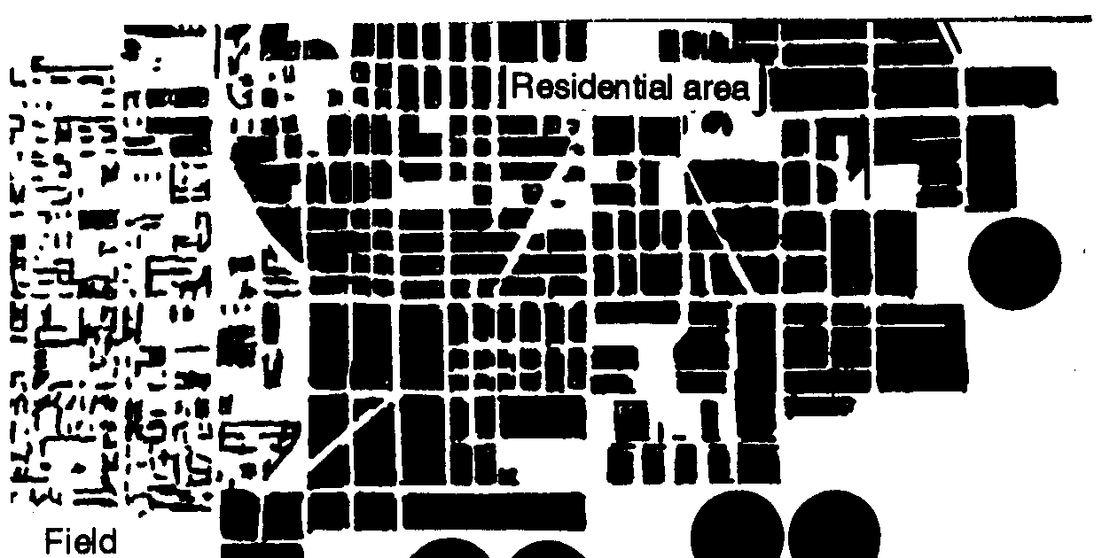
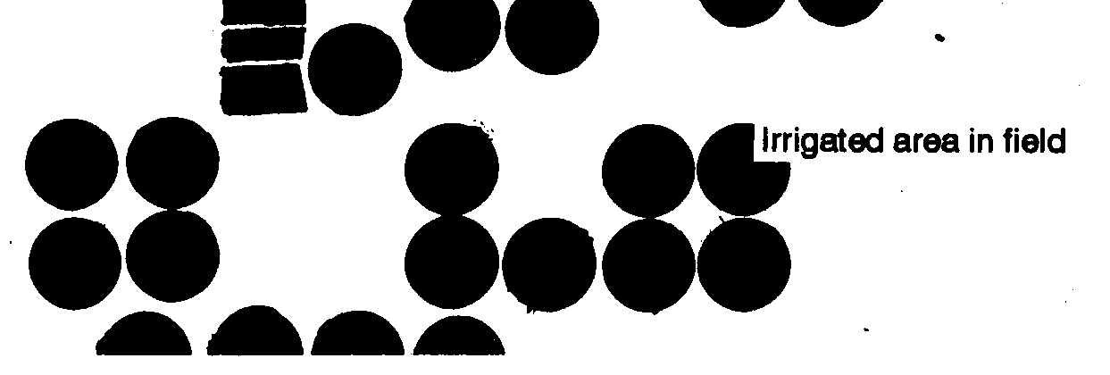
(10) Wells. One of the best indicators of groundwater is groundwater development with well systems. Water wells are difficult to detect, especially from imagery. It is possible to detect wells indirectly from irrigation patterns. Pivot irrigation patterns (Figure 2-34) are distinctive and are
usually supplied by centrally located water-supply wells. Such features are good indications that quality groundwater is present at economic pumping depths.
(11) Reservoirs and Lakes. Surface water bodies can be groundwater recharge, discharge, or both artificial surface-water reservoirs usually capture surface water and represent areas of 2-32

FM 5-484/NAVFAC P-1065/AFMAN 32-1072
recharge, as do natural reservoirs
created by the damming of
streams. Natural reservoirs in
lowland areas are often formed by
the discharge of groundwater from
seeps along the lake bed or from
springs.
(12) Crop Irrigation. Crop
irrigation indicates the use of
surface or groundwater for
agriculture.
In most arid
environments, surface-water-
based irrigation is located adjacent
to streams and rivers. Beyond the
river floodplains, agriculture is
negligible.
Agricultural
development in areas without
surface water is a good indicator of
the presence of groundwater at
relatively shallow depths. The leaching action of irrigated water and the use of chemical fertilizers may impair the groundwater quality in such areas.
(13) Population Distribution. Population distribution in arid regions or sparsely populated areas is closely related to water availability. Because of the lack of resources and technical capabilities for wide-scale groundwater development projects, population centers in arid environments without surface water are usually good indicators of groundwater supplies. These centers are often located on perched aquifers with limited capabilities; the population sizes are direectly proportional to the production capacities of the aquifers.
2-8. Desert Environments. For contingency, water-well drillers must become familiar with drilling operations in an arid or desert environment. An arid environment usually has less than 300
millimeters (mm) of rainfall per year and high average daily temperatures. Most of the soils are coarse-grained with high porosity and permeability. Because of low rainfall, only deep water tables may exist. Therefore, any well-drilling units and equipment or kits deployed to a desert AO should be capable of achieving maximum depth of 1,500 feet.
Generally, the more arid the region, the greater the controls the host nation will place on well-drilling activities because of the potential impact of drilled wells depleting scarce aquifers. The host nation may also require more detailed documentation on the water sources. Because of the amount of water consumed during desert operations (up to 20 gallons daily per person), the challenge may not be in locating and drilling for water, but in finding who can identify water sources and give permission for using the sources.
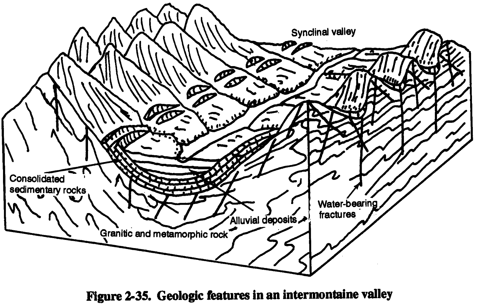
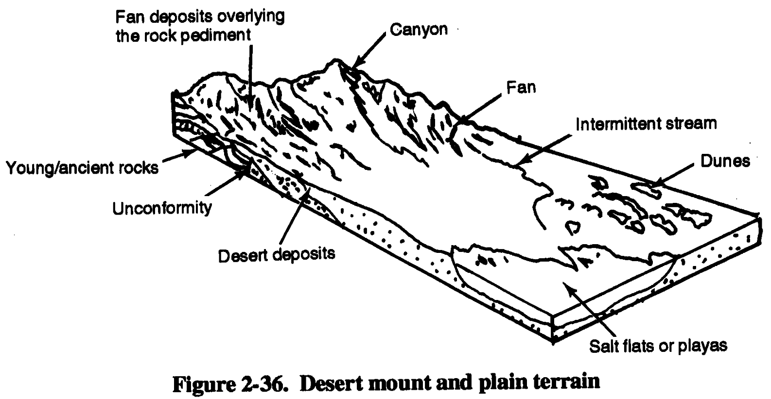
In desert mountain areas, wells should be sited on the alluvial fans that extend from the
mountains to the desert (Figure 2-35, page 2-34). Mountain areas usually receive more rainfall, and
the streams draining away from the mountains carry coarse gravels and sands that, when deposited,
produce the fans (Figure 2-36, page 2-34). At moderate depths, these fans may yield water. In
2-33
FM 5-484/NAVFAC P-1065/AFMAN 32-1072
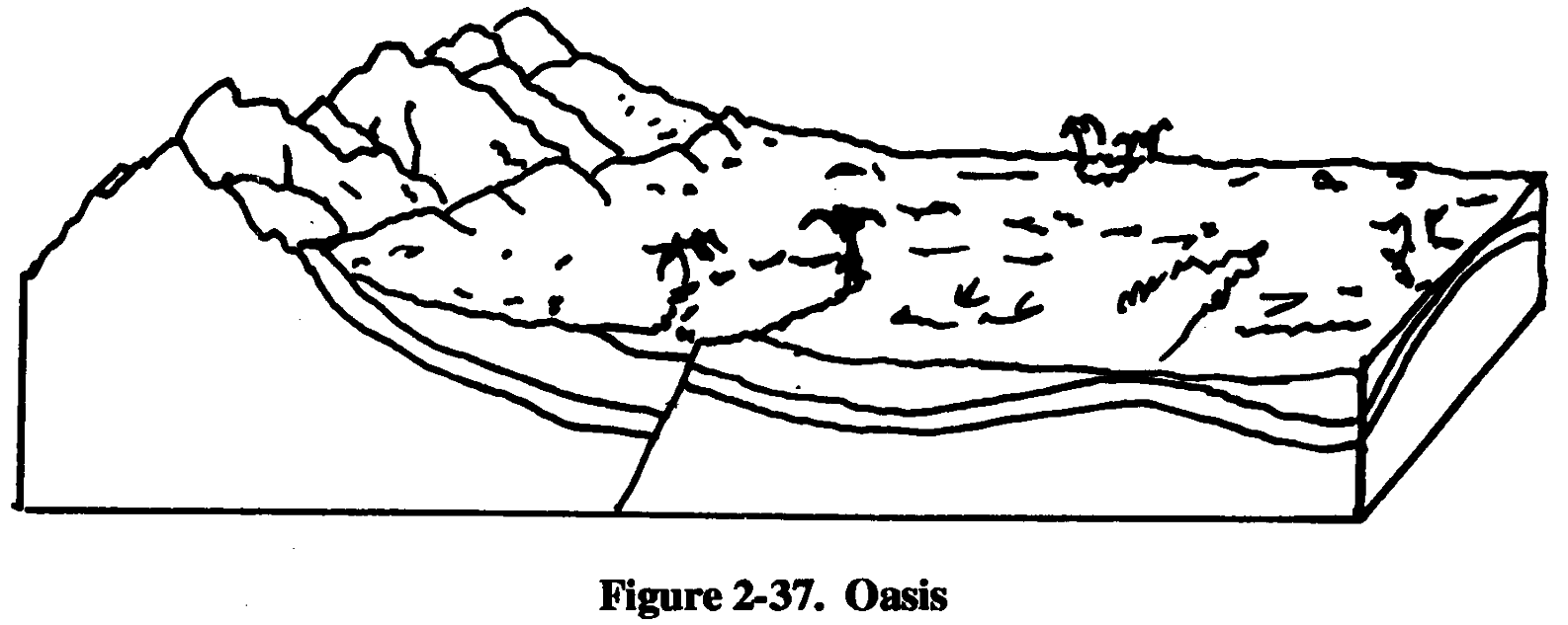
deserts such as in Egypt, Jordan, and Saudi Arabia, deep confined aquifers are capable of producing extensive quantities of water. Locally, shallow confined aquifers come to the surface at an oasis,
characterized by more extensive vegetation than the surrounding areas (Figure 2-37). Wells may
be sited in the vicinity of an oasis to tap the confined aquifer.
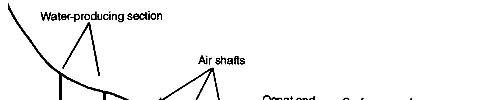
Qanats are good indicators of groundwater in some desert areas like Iran. A qanat is a man-made, gently inclined underground channel that allows groundwater to flow from alluvial gravels
photographs, qanats appear as a series of ant-mound- like openings that run in a straight line and act as air shafts for the channel. They may be found in arid regions of Southwest Asia and North Mica.
Qanats may be up to 30 kilometers in length.
2-34


FM 5-484/NAVFAC P-1065/AFMAN 32-1072
2-9. Water Quality. Most water is run through reverse osmosis water purification units (ROWPU) before it is used, so the effect of contamination is minimal.
a. Aquifer Contamination.
Military engineers must be aware of possible aquifer
contamination. As groundwater is transmitted from recharge to discharge areas, it contacts soils and rocks of the earth’s crust. Contact causes some dissolution of soil and rocks into the water and alters the chemistry of the groundwater. Discharge areas that appear to be good well sites because of shallow groundwater may have poor water quality and may be poor sites for groundwater development. Discharge areas often correspond to zones of poor water quality. Generally, the longer the distance between the recharge and discharge areas, the poorer the water quality at the discharge area. The water-quality reduction is from the contact between the groundwater and the 2-35
FM 5-484/NAVFAC P-1065/AFMAN 32-1072
aquifer material during flow. Water consumption by plants often results in decreased water quality by the concentration of soluble salts in the groundwater.
In very shallow groundwater (less than 10 feet below land surface), water quality can be decreased by direct evaporation of water from the soil. Vegetation type can be used to infer groundwater quality characteristics. Saltbush around playas indicates not only the presence of shallow groundwater but also the probable occurrence of saline water, which would require treatment. The high evaporation rate in arid environments concentrates chemicals in the water, resulting in brackish or saline water quality.
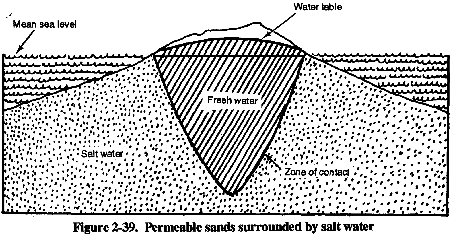
b. Saltwater Intrusion. Saltwater intrusion into fresh groundwater is a problem in coastal areas and on islands. Saltwater is unfit for most human use and is harmful to automotive cooling systems, boilers, and other types of machinery. Chemical analysis determines the accuracy of contamination and salt levels. The average concentration of dissolved solids in sea water is about 35,000 parts per million (ppm) (3.5 percent). Most salts are chlorides.
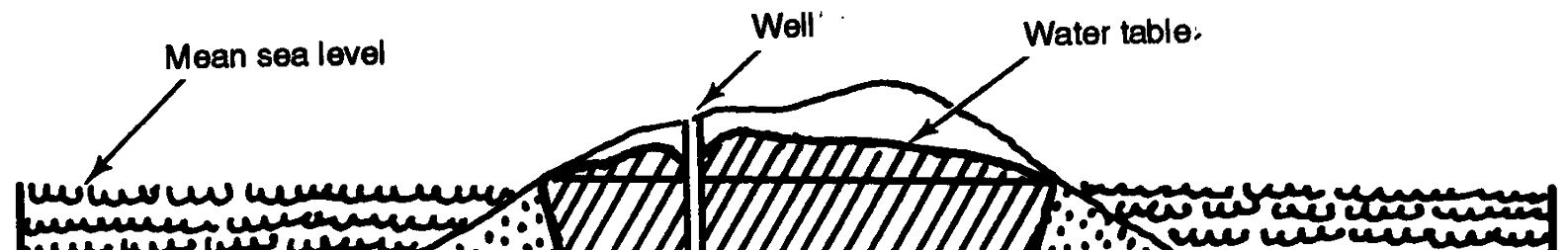
When salt water and fresh water are present in sediments, fresh water floats on salt water.
Contact between the two is determined by the head of the fresh water above sea level and by the relatively greater specific gravity of the salt water. The average specific gravity of sea water is about 1.025 (taking pure water as 1.000). For every foot of fresh water above sea level about 40
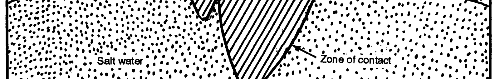
feet of freshwater is below sea level in homogeneous soils. The condition is best exhibited by small islands and peninsulas composed of permeable sands surrounded and underlain by salt water (Figure 2-39). The head of fresh water and resistance of the pores in sand prevents saltwater from entering the middle zone and mixing with fresh water. The diffusion zone (contact) between fresh water and salt water is narrow (less than 100 feet wide) unless affected by heavy pumping.
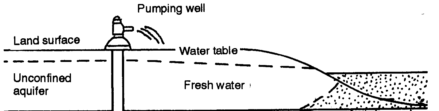
The amount of freshwater that can be pumped without intrusion of salt water depends on local conditions, type of well, rate of pumping, and the rate of recharge by fresh water. Any decrease in
the head of fresh water by pumping or decrease in rainfall raises the saltwater level (Figure 2-40).
The cone of depression (drawdown) produced in the freshwater level around a well allows a corresponding rise in the underlying salt water. Pumping a well should be restricted because salt 2-36