Geography Grade 4 by Siyavula Uploader - HTML preview
Download the book in PDF, ePub, Kindle for a complete version.
Town planning
People who are responsible for designing towns and cities, are called town planners. Apart from determining where suburbs, industrial areas and the central business core should be situated, they must also see that land is made available for churches, schools, recreational areas, sports fields, streets, parking areas, and services such as railway lines, electricity supply, telephone
communication, sewerage, etc. There are many aspects that town planners must keep in mind.
On official town or city maps land utilization is indicated in different colours. By means of the various colours, we can determine whether a specific section is used as an area for living or for industrial use.
Activity 2
To compare urban and rural settlements [LO 1.1, 1.3]
This table indicates which colours should be used for the different areas on a land utilization map.
Colour the table in the prescribed colours and then colour in the land utilization map in the correct colours.
Table 2.6.
1.
Business Sector
(dark blue)
2.
Industrial Area
(purple)
3.
High density occupation (orange)
(not numbered) Single occupation
(yellow)
5.
Sports and recreation
(dark green)
6.
Public open space
(light green)
7.
Agricultural land
(dark green outline)
8.
Schools
(grey)
9.
Churches
(grey // 45o black shading)
Land Use Map
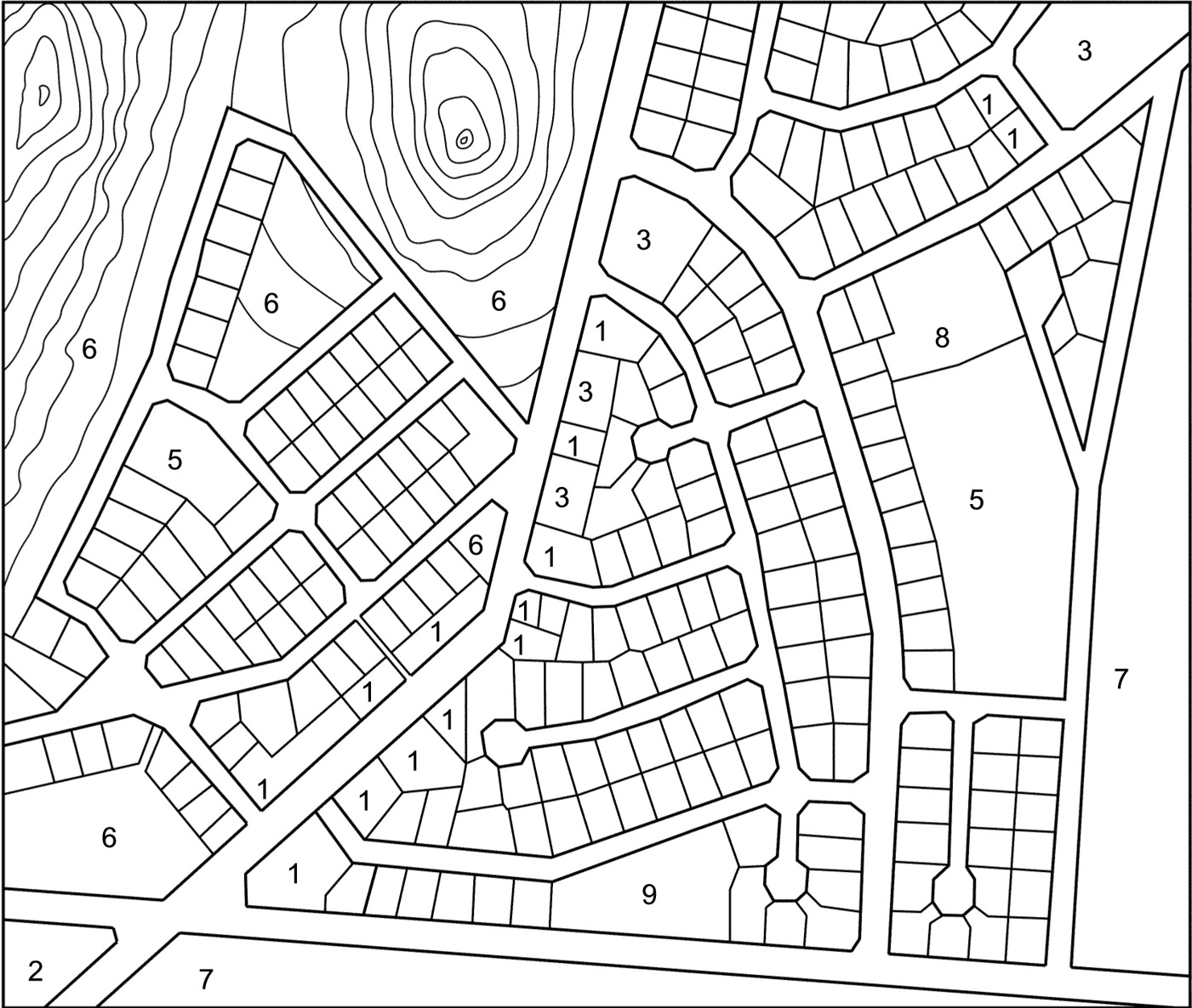
Figure 2.5.
Explanation: To help you to identify land utilization, numbers are used.
All the plots without numbers are for general occupancy (residential areas).
Activity 3
To complete a land utilization map of your own environment [LO 1.1, 1.3]
Make a copy of a street plan of your town or suburb, e.g. the area where your school or home is located. Use only a section of the map. Use the same colours as for the previous activity and complete the land utilization map.
Go for a walk through your town, or try to do it the way you remember it, or from your discussion as a group.
After you have completed your map, you can compare it with a friend’s map.
Activity 4
To make suggestions of how to improve land utilization [LO 1.7, 2.2, 2.3]
In many towns and suburbs there is land that has not been utilized properly. It could be a
riverbank that has not been developed as a proper recreational facility, or simply not cared for and therefore it is not an attractive nature spot.
Identify a neglected piece of land in your environment. Discuss as a group how it could be
transformed into a recreational area or a nature reserve. Make a sketch to explain your proposal to your partners. Use the correct colours (look at activity 1 again) to colour in your plan to improve the area, as well as the surrounding area.
Compile the rules that will make it pleasant for people who visit the area.
Our rules
1. ………………………………………………………………………………
………………………………………………………………………………
2. ………………………………………………………………………………
………………………………………………………………………………
3. ………………………………………………………………………………
………………………………………………………………………………
4. ………………………………………………………………………………
………………………………………………………………………………
5. ………………………………………………………………………………
………………………………………………………………………………
6. ………………………………………………………………………………
………………………………………………………………………………
7. ……………………………………………………………………………….
……………………………………………………………………………….
8. ……………………………………………………………………………….
……………………………………………………………………………….
9. ……………………………………………………………………………….
……………………………………………………………………………….
10. ………………………………………………………………………………
………………………………………………………………………………
Assessment
LEARNING OUTCOME 1: GEOGRAPHICAL ENQUIRY
The learner will be able to use enquiry skills to investigate geographical and
environmental concepts and processes.
Assessment Standard
We know this when the learner:
1.1 identifies information from various sources (maps, atlases, books);
1.3 identifies symbols used in different kinds of maps (including plan view, grids and map keys)
[works with sources];
1.7 uses geographical and environmental concepts and terms to report on enquiries in different ways (e.g. writing a paragraph, using a poster, artwork).
LEARNING OUTCOME 2: GEOGRAPHICAL KNOWLEDGE
AND UNDERSTANDING
The learner will be able to demonstrate geographical and environmental knowledge and
understanding.
Assessment Standard
We know this when the learner:
describes the features of the local settlement, including land uses, and compares them with examples from other places;
describes the importance of access to resources and services for people living in settlements; 2.3 describes how basic human needs were met in the past and at present.
Memorandum
Land use
The different areas in a town/city
Table 2.7.
Central business core
Industrial area
Residential area
Large office complexes Large factories
Flats
Shopping centres
Smaller storage places Houses
Businesses
Workshops
Townhouses
Storage places
2.5. Transport*
GEOGRAPHY
Grade 4
THE PLACE WHERE WE LIVE
(SETTLEMENT CHARACTERISTICS)
Module 12
TRANSPORT
Transport
Types of transport
Transport is needed to move people and goods from one place to the other. Our parents must get to their work and we must get to school. Fresh bread and milk must be delivered daily to the café /
superette. Postal items must be transported worldwide everyday.
Activity 1
To compile a list of different kinds of transport [LO 2.2, 3.2]
Compile a list of all the means of transport that you can think of, and indicate those that you make use of.
K inds of T ransport
1. …………………………………………………………………………………
2. …………………………………………………………………………………
3. …………………………………………………………………………………
4. …………………………………………………………………………………
5. …………………………………………………………………………………
6. …………………………………………………………………………………
7. ………………………………………………………………………………….
8. ………………………………………………………………………………….
Compare your list to that of your partner and extend your list with his/her examples
1.Transport statistics
Consult the learners in your class/grade for the following investigation.
Activity 2
To classify information under headings [LO 1.2, 1.6]
How do you get to school in the morning??
Table 2.8.
Name of
With my parents’
With a friend’s parents’
With a
With a
Other
learner
car
car
bus
taxi
1.
2.
3.
4.
5.
6.
7.
8.
9.
10.
Table 2.9.
Total
Activity 3
To compile a graph [LO 1.7]
Compile a graph by using the above totals.
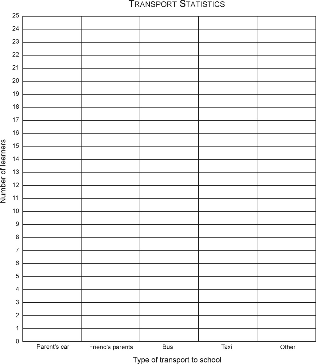
Figure 2.6.
2.Roads
To move people and goods successfully from one point to another, an extensive road network is needed. For busy routes roads should preferably have two or even three lanes, while single lane roads are suitable for light traffic in residential areas. Roads must be well maintained.
Activity 4
To answer questions about a road in your town [LO 2.1]
Identify one road in your town/city and answer the following questions about the road:
How wide and how long is the road?
……………………………………………………………………………………..
Are there road markings on the road?
……………………………………………………………………………………..
Which places does the road connect?
……………………………………………………………………………………..
What type of road is it (national, regional, local)?
……………………………………………………………………………………..
Who uses the road?
……………………………………………………………………………………..
What is the name of the road?
……………………………………………………………………………………..
Mainly what kinds of vehicles use the road?
…………………………………………………………………………………….
Who is responsible for the maintenance of this road?
………………………………………………………………………………………..
Activity 5
To draw your own road map [LO 1.5]
Identify an area around the road you identified in the previous activity and draw a simple road map of the area. Remember to include the names of streets and other important landmarks.
Assessment
LEARNING OUTCOME 1: GEOGRAPHICAL ENQUIRY
The learner will be able to use enquiry skills to investigate geographical and
environmental concepts and processes.
Assessment Standard
We know this when the learner:
1.2 organises information under given headings;
1.6 uses information from sources (including own observations) to answer questions about people and places (e.g. “Why is it like that?”).
LEARNING OUTCOME 2: GEOGRAPHICAL KNOWLEDGE
AND UNDERSTANDING
The learner will be able to demonstrate geographical and environmental knowledge and
understanding.
Assessment Standard
We know this when the learner:
describes the features of the local settlement, including land uses, and compares them with examples from other places;
describes the importance of access to resources and services for people living in settlements.
LEARNING OUTCOME 3: EXPLORING ISSUES
The learner will be able to make informed decisions about social and environmental issues and problems.
Assessment Standard
We know this when the learner:
3.2 identifies the factors that influence why some people have better access to resources compared to others in a particular context.
Solutions
Chapter 3. Term 3
3.1. What are resources? *
GEOGRAPHY
Grade 4
RESOURCES AND SERVICES WITHIN A SETTLEMENT
Module 13
WHAT ARE RESOURCES?
Resources
What are resources? Definition:Resources are things we need to do/make things
Are the following all resources? Look at the definition again and first discuss the possible answers with a friend.
Table 3.1.
copper
fish
oil
wood
water
the son
wind
sand
lime
aluminium
coal
ground
cattle manure gold
gas
iron
Another resource: People
What can happen without the manager and the worker? Nothing!
Remember: because people are an important resource, they must be well looked after, but nature provides the other resources – they must also be well looked after. More about this later!
Result of test:
Perhaps you and your friend had a nice argument about what resources are. The one who did the best is the one who said that all sixteen are resources.
Activity 1
To identify resources in our daily lives [LO 2.1]
Think a bit and add some more to each group (your educator will help you):
Resources that help us to produce food:
soil, phosphates (for making fertiliser), water, manure
………………………………………………………………………………
………………………………………………………………………………
………………………………………………………………………………
Resources that help us to warm ourselves and cook food:
coal, wood, oil, gas
………………………………………………………………………………….
………………………………………………………………………………….
………………………………………………………………………………….
Resources that help us to produce equipment for the home:
wood, metals, coal, oil
………………………………………………………………………………….
…………………………………………………………………………………………
Resources that help us to produce equipment for the classroom:
coal, wood, metals
………………………………………………………………………………………….
………………………………………………………………………………………….
………………………………………………………………………………………….
Very important:
Think carefully about all the resources mentioned – also those you added – and write down the resources that cannot be exhausted. You will learn more about it in Grade 5.
………………………………………………………………………………………….
………………………………………………………………………………………….
…………………………………………………………………………………………..
There are so many poor people in South Africa and in the rest of Africa who dry cattle manure in cakes to make a fire that it can also be named as a source of energy.
Map work
Activity 2
To study the map of South Africa and to answer the questions [LO 1.1]
Natural resources in South Africa
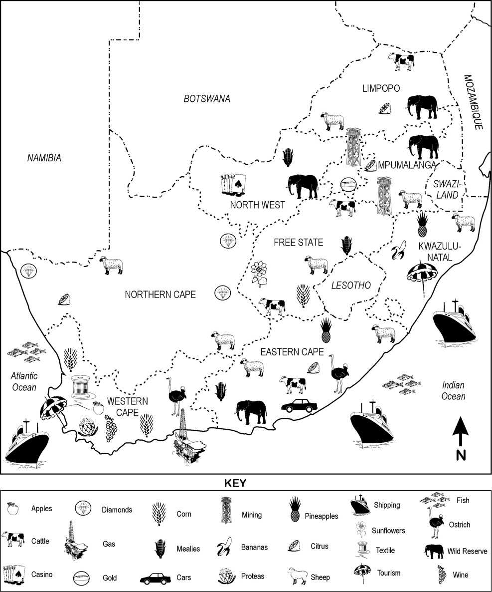
Figure 3.1.
Which mines are found in Gauteng? …………………………………………..
Which mines do we find in the North Cape? ………………………………….
What type of farming is found in the Free State? …………………………….
Which animal resources are found in your province? ……………………….
In which province do we find hardly any farming? (Try to give a reason for your answer.)
…………………………………………………………………………….
Assessment
LEARNING OUTCOME 1: GEOGRAPHICAL ENQUIRY
The learner will be able to use enquiry skills to investigate geographical and
environmental concepts and processes.
Assessment Standard
We know this when the learner:
1.1 identifies information from various sources (maps, atlases, books).
LEARNING OUTCOME 2: GEOGRAPHICAL KNOWLEDGE AND UNDERSTANDING
The learner will be able to demonstrate geographical and environmental knowledge and
understanding.
Assessment Standard
We know this when the learner:
describes the features of the local settlement, including land uses, and compares them with examples from other places.
Memorandum
Resources in our daily lives
Sun
Seed
Lime
Sun
Paraffin
Animal hides
Glass
Rubber
Very important:
Sun
Soil
Water (if we look after it)
The map of South Africa
Gold
Diamonds
Sheep, cattle, maize, wheat, sunflowers
Northern Cape - dry
3.2. Water in our houses*
GEOGRAPHY
Grade 4
RESOURCES AND SERVICES WITHIN A SETTLEMENT
Module 14
WATER IN OUR HOUSES
Water as a resource
Without water life on earth is not possible. Water is also the ingredient or substance found in the largest quantities on earth – it covers almost 80% of the surface of our planet. Only 3% of the 80%
is fresh water, and most of this fresh water is found in frozen form, namely the ice-fields at the North and South Poles.
Some interesting facts:
Between 60% and 70% of our bodies consist of water.
85% of our brains is water.
25% of our bone structures is water.
83% of our blood is water.
A human being can survive for longer than two weeks without food, but only three days without water.
A human being loses an average of 2,5 litres of water due to perspiration, respiration and waste.
1.Water in our houses
Now that you have been introduced to these interesting facts about human beings and water, are you convinced that water is the most important resource? Discuss it in class.
Activity 1
To discuss water in and around our homes [LO 2.2]
What does your family need water for? Talk to your partner about your needs, and then answer the following questions:
Water for our family
1. We all drink water.
2. Mother uses water when she cooks food.
3. …………………………………………………………………………………
4. …………………………………………………………………………………
5. …………………………………………………………………………………
6. …………………………………………………………………………………
7. …………………………………………………………………………………
8. …………………………………………………………………………………
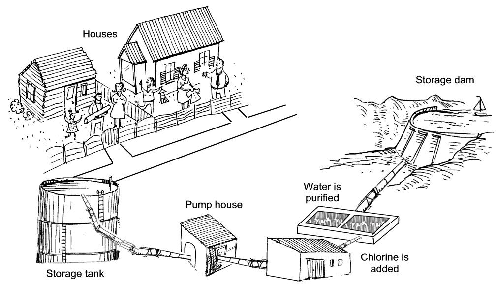
2.Where does your water come from?
Figure 3.2.
When it rains, water flows along rivers and streams to eventually end up in great dams that were built in the rivers. They are called storage dams. From these storage dams the water is transported in enormous pipes to water works where the necessary purification of the water takes place. From there the water is transported along smaller pipes to cities and towns and eventually to our homes.
Which storage dam(s) is/are nearest to you? Write down the name(s) of the dam(s):
Access to water
Activity 2
To identify the reasons why some people have better access to clean water than
others [LO 3.2]
Our government spends large amounts of money to supply clean water to all the people of our country for drinking household use. The ideal is that each household should have running water that is clean and safe in their homes.
However, there are still many people that have to walk long distances to fetch water in
containers and carry them home. Often the water is taken from rivers that are polluted by
people, animals and factories. The polluted water causes diseases from which people can die.
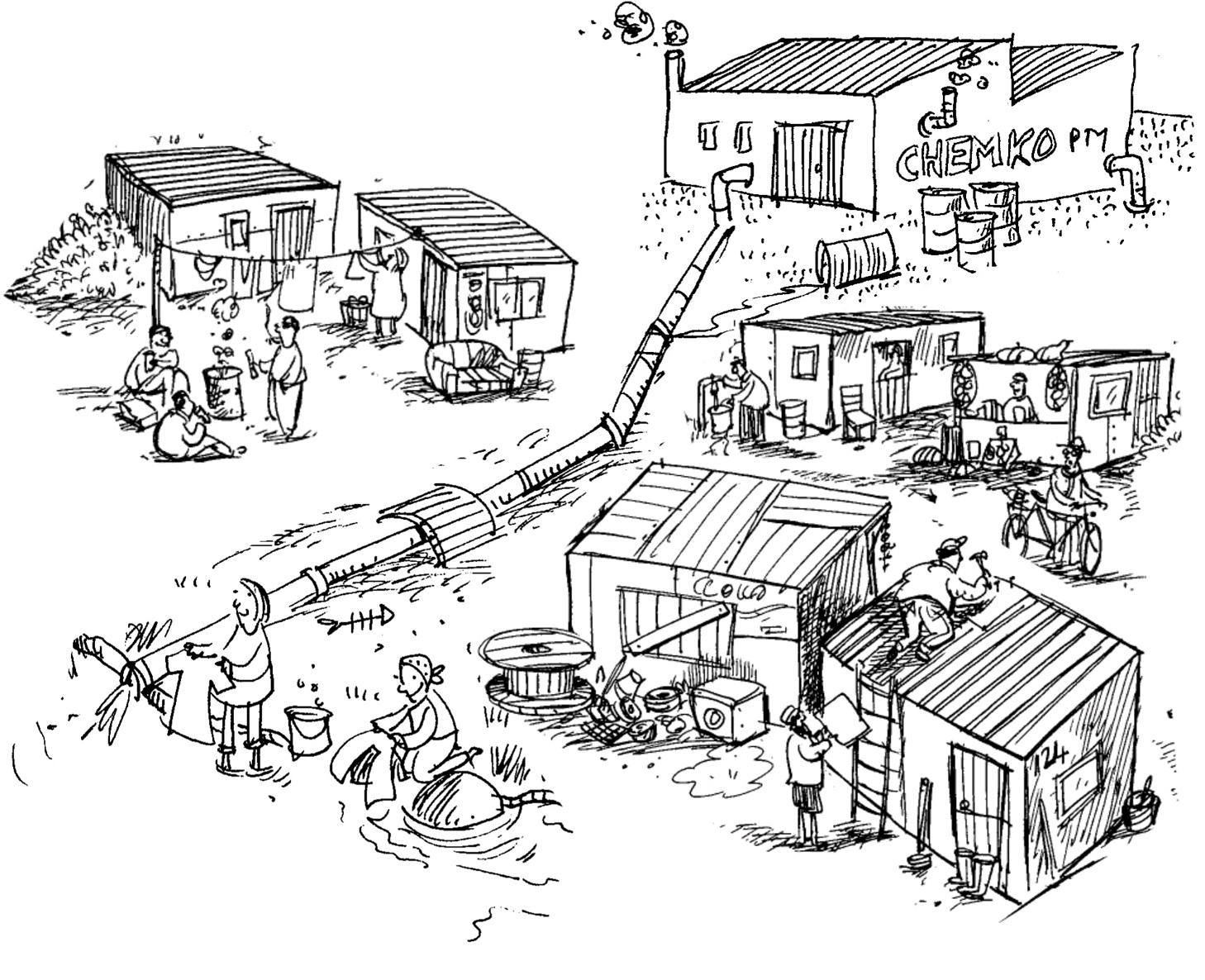
Informal settlements are established and develop so rapidly that the local governments cannot supply running water immediately. The people build their shelters close to open water sources such as rivers. Everybody then uses the same source. People not only take their drinking water from the source, but also wash themselves and their washing in the same water. Children play and swim in the water, and animals contaminate the water. Often waste from factories is dumped into the source.
Figure 3.3.
Assessment
LEARNING OUTCOME 2: GEOGRAPHICAL KNOWLEDGE
AND UNDERSTANDING
The learner will be able to demonstrate geographical and environmental knowledge and
understanding.
Assessment Standard
We know this when the learner:
describes the importance of access to resources and services for people living in settlements.
LEARNING OUTCOME 3: EXPLORING ISSUES
The learner will be able to make informed decisions about social and environmental issues and problems.
Assessment Standard
We know this when the learner:
3.2 identifies the factors that influence why some people have better access to resources compared to others in a particular context.
Memorandum
Water in and around our homes
1. Purification (cleansing purposes)
2. Garden
5. Swimming pool