Father Thames by Walter Higgins - HTML preview
Download the book in PDF, ePub, Kindle for a complete version.
INTRODUCTION
The River and its Valley
ENGLAND is not a country of great rivers. No mighty Nile winds lazily across desert and fertile plains in its three and a half thousand miles course to the sea; no rushing Brahmaputra plunges headlong down its slopes, falling two or three miles as it crosses half a continent from icy mountain-tops to tropical sea-board. In comparison with such as these England’s biggest rivers are but the tiniest, trickling streams. Yet, for all that, our little waterways have always meant much to the land. Tyne, Severn, Humber, Trent, Thames, Mersey, Ouse—all these, with many smaller but no less well-known streams, have played their part in the making of England’s history; all these have had much to do with the building up of her commercial prosperity.
One only of these rivers we shall consider in this book, and that is old “Father Thames”: as it was and as it is, and what it has meant to England during two thousand years. In our consideration we shall divide the River roughly into three quite natural divisions—first, the section up to the lowest bridge; second, the part just above, the part which gave the River its chief port and city; third, the upper river.
However, before we consider these three parts in detail, there is one question which we might well ponder for a little while, a question which probably has never occurred to more than a few of us; and that is this: Why was there ever a River Thames at all? To answer it we must go back—far, far back into the dim past. As you know, this world of ours is millions of years old, and like most ancient things it has seen changes—tremendous changes. Its surface has altered from time to time in amazing fashion. Whole mountain ranges have disappeared from sight, and valleys have been raised to make fresh highlands. The bed of the ocean has suddenly or slowly been thrust up, yielding entirely new continents, while vast areas of land have sunk deep enough to allow the water to flow in and create new seas. All this we know by the study of the rocks and the fossil remains buried in them—that is, by the science of geology.
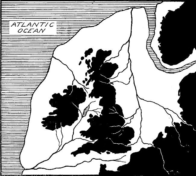
Now, among many other strange things, geology teaches us that our own islands were at one time joined on to the mainland of Europe. In those days there was no English Channel, no North Sea, and no Irish Sea. Instead, there was a great piece of land stretching from Denmark and Norway right across to spots miles out beyond the western limits of Ireland and the northern limits of Scotland. This land, which you will best understand by looking carefully at the map, p. 4, was crossed by several rivers, the largest of them one which flowed almost due north right across what is now the North Sea. This river, as you will see from the map, was chiefly produced by glaciers of the Alps, and, in its early stages, took practically the same course as the River Rhine of these days. As it flowed out across the Dogger district (where now is the famous Dogger Bank of our North Sea fishermen) it was joined by a number of tributary rivers, which flowed down eastwards from what we might call the “back-bone of England”—the range of mountains and hills which passes down through the centre of our islands. One of these tributaries was a river which in its early stages flowed along what is now our own Thames Valley.
In those days everything was on a much grander scale, and this river, though only a small tributary of the great main continental river, was a far wider and deeper stream than the Thames which we know. Here and there along the present-day river valley we can still see in the contours of the land and in the various rocks evidences of the time when this bigger stream was flowing. (Of this we shall read more in Book III.) Thus things were when there came the great surface change which enabled the water to flow across wide tracts of land and so form the British Islands, standing out separately from the mainland of Europe.
All that, of course, happened long, long ago—many thousands of years before the earliest days mentioned in our history books—at a time about which we know nothing at all save what we can read in that wonderful book of Nature whose pages are the rocks and stones of the earth’s surface.
By the study of these rocks and the fossil remains in them we can learn just a few things about the life of those days—the strange kinds of trees which covered the earth from sea to sea, the weird monsters which roamed in the forests and over the hills. Of man we can learn very little. We can get some rough idea of when he first appeared in Britain, and we can tell by the remains preserved in caves, etc., in some small degree what sort of life he lived. But that is all: the picture of England in those days is a very dim one.
How and when the prehistoric man of these islands grew to some sort of civilization we cannot say. When first he learned to till the soil and grow his crops, to weave rough clothes for himself, to domesticate certain animals to carry his goods, to make roads along which these animals might travel, to barter his goods with strangers—all these are mysteries which we shall probably never solve.
Just this much we can say: prehistoric man probably came to a simple form of civilization a good deal earlier than is commonly supposed. As a rule our history books start with the year of Cæsar’s coming (55 B.C.), and treat everything before that date as belonging to absolute savagery. But there are many evidences which go to show that the Britons of that time were to some considerable extent a civilized people, who traded pretty extensively with Gaul (France, that is), and who knew how to make roads and embankments and, perhaps, even bridges.
As early man grew to be civilized, as he learned to drain the flooded lands by the side of the stream and turn them from desolate fens and marshes to smiling productive fields, and as he learned slowly how to get from the hillsides and the plain the full value of his labour, so he realized more and more the possibilities of the great river valley.
The Thames flows in what may be regarded as an excellent example of a river-basin. A large area, no less than six thousand square miles, is enclosed on practically all sides by ranges of hills, generally chalk hills, which slope down gently into its central plain; and across this area, from Gloucestershire to the North Sea, for more than two hundred miles the River winds slowly seawards, joined here and there by tributaries, which add their share to the stream as they come down from the encompassing heights.
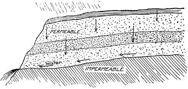
On the extreme west of the basin lie the Cotswold Hills of Gloucestershire. Here the Thames is born. The rain which falls on the hill-tops makes its way steadily into the soil, and is retained there. Down and down it sinks through the porous limestone and chalk, till eventually it reaches a layer of impenetrable material—clay, slate, or stone—through which it can no longer pursue its downward course. Its only way now is along the upper surface of the stratum of impermeable material. Thus it comes in time to the places on the hillsides where the stratum touches the open air (see diagram on p. 8), and there it gushes forth in the form of springs, which in turn become tiny streams, some falling westwards down the steep Severn valley, others running eastwards down the gentler declivity.
At their northern end the Cotswolds sweep round to join Edge Hill; and then the hill-wall crosses the uplands of that rolling country which we call the Central Tableland, and so comes to the long stretch of the East Anglian Heights, passing almost continuously eastward through Hertfordshire and North Essex to Suffolk. On the south side the ring of hills sweeps round by way of the Marlborough Downs, and so comes to the long scarp of the “North” Downs, which make their way eastwards to the Kentish coast.
Within the limits of this ring of hills the valley lies, not perfectly flat like an alluvial plain, but gently, very gently, undulating, seldom rising more than two or three hundred feet above sea-level, save where that great ridge of chalk—the Chiltern-Marlborough range—straddles right across the basin at Goring.
Standing on one of the little eminences of the valley we can survey the scene before us: we can watch the River for many miles winding its way seawards, and note in all directions the same fertile, flourishing countryside, with its meadows where the soft-eyed cattle browse on the rich grass; its warm, brown plough-lands; its rich, golden fields of wheat, oats, and barley; its pretty orchards and farms close at hand; its nestling, tidy villages; its little pointed church steeples dotted everywhere. We can see in the distance, maybe, one or two compact little towns, for towns always spring up on wide, well-farmed plains, since the farmers must have proper markets to which to send their supplies of eggs, butter, cheese, and milk, and proper mills where their grain may be ground into flour.
It is a pleasant, satisfying prospect—one which suggests industrious, thrifty farmers reaping the rich reward of their unsparing labours; and it is an interesting prospect, too, for this same prosperous countryside, very little altered during half-a-dozen centuries, has done much to establish and maintain the position of the Thames as thegreat river of England.
The usefulness of a river to its country depends on several things. In the first place, it must be able to carry goods—to act as a convenient highway along which the traffic can descend through the valley towards the busy places near the mouth. That is to say, it must be navigable to barges and small boats throughout a considerable portion of its length. In the second place, there must be the goods to carry. That is to say, the river must pass through a countryside which can produce in great quantity things which are needed. In the third place, the chief port of the river must lie in such a position that it is within comparatively easy distance of good foreign markets.
Now let us see how these three conditions apply to the River Thames.
Firstly, with regard to the goods themselves. If we take our map of England, and lay a pencil across it from Bristol to the Wash, we shall be marking off what has been through the greater part of English history the boundary of the wealthy portion of Britain, for only in modern times, since the development of the iron and coal fields, and the discovery that the damp climate of the north was exactly suited to the manufacture of textiles, has the great industrial North of England come into being. England in the Middle Ages, and on till a century or more ago, was an agricultural country; its wealth lay very largely in what it grew and what it reared; and the south provided the most suitable countryside for this sort of production. The consequence was that the Thames flowed right down through the centre of wealthy England. All round it were the chalk-ranges on which throve the great herds of long-fleeced sheep that provided the wonderful wool for which England was famous, and which was in many respects the main source of her prosperity. In between the hills were the cornfields and the orchards. And dotted all down the course at convenient points were thriving towns, each of which could, as it were, drain off the produce of the area behind it, and so act as a collecting and forwarding station for the traffic of the main stream.
The River, too, was quite capable of dealing with the great output, for it was navigable for barges and small boats as far as Lechlade, a matter of 150 miles from the mouth, and its tributaries were in most cases capable of bearing traffic for quite a few miles into the right and left interior. Moreover, its current at ordinary times was neither too swift nor too sluggish.
So that, with the wealth produced by the land and the means of transport provided by the River, the only things needed to make the Thames one of Europe’s foremost rivers were the markets.
Here again the Thames was fortunate in its situation, for its mouth stood in an advantageous position facing the most important harbours of Normandy, Flanders, Holland, and Germany, all within comparatively easy distance, and all of them ready to take our incomparable wool and our excellent corn in exchange for the things they could bring us. Moreover, the tides served in such a way that the double tides of the Channel and the North Sea made London the most easily reached port of all for ships coming from the south.
Thus, then, favoured as it was by its natural situation and by its character, the Thames became by far the most important highway in our land, and this it remained for several centuries—until the coming of the railways, in fact.
Now the River above London counts for very little in our system of communications. Like all other English waterways, canals and rivers alike, it has given place to the iron road, notwithstanding the fact that goods can be carried by water at a mere fraction of the cost of rail-transport. But our merchants do not seem to realize this; and so in this matter we find ourselves a long way behind our neighbours on the Continent.