Geography Grade 7 by Siyavula Uploader - HTML preview
Download the book in PDF, ePub, Kindle for a complete version.
tropical cyclone disaster area. Devise a plan to help the affected people. What would be the first measures to take? How much time would your rescue operation take?
2. Which precautionary measures can be taken to minimise the effect of tropical cyclones? Study the cyclone-warning pamphlet on p. 23 that is issued by the American Weather Bureau to
assist you.
Figure 1.7.
Assessment
Table 1.3.
Learning Outcomes(LOs)
LO 2
GEOGRAPHICAL KNOWLEDGE AND UNDERSTANDINGThe learner will be able to
demonstrate geographical and environmental knowledge and understanding.
Assessment standards(ASe)
We know this when the learner:
2.1 describes and explains how natural hazards such as volcanoes, earthquakes and flooding
occur, and their impact on human lives and socio-economic activities [people and places];2.2
investigates and explains why some people face a higher risk than others with respect to natural hazards [people and resources];2.3 identifies how risks and hazards can be managed [people and the environment].
Memorandum
Activity 1:
1. The effects of tropical cyclones:
Loss of lives among human beings and animals;
Rivers overflow and towns near rivers are also flooded or even destroyed;
Decaying bodies cause pollution and health hazards;
Bridges and roads are washed away;
Electricity, water and sewage services are interrupted;
Houses and other buildings are destroyed or severely damaged;
Crops are destroyed;
Gale force winds blow away roofs and uproot trees and shrubs. This is also dangerous as people might get injured;
No fresh water or food. This leads to famine and death.
1. Tropical cyclones originate in warm, humid tropical oceans. The strong winds cause gigantic waves in the oceans. These waves flood the coastal areas and cause enormous damage.
As soon as the tropical cyclone reaches the land, it has no warm, humid sea air to thrive on, and it dies away. That’s why there will still be gales for quite a time, but they subside as the cyclone dies.
1. The area of calm, cloudless skies in the middle (centre) of a tropical cyclone is called the
“eye”. It has a width of about 35-50 km. Here the pressure is less than 1 000 kPa. The area
directly around the eye is where the strongest gales occur.
Activity 2:
During tropical cyclones most deaths occur because of the floods. Rivers that suddenly come
down may unexpectedly flood a region.
Some people try to cross a river which is in flood and are washed away by the water masses.
Gale force winds that blow away roofs and other items, may also cause deaths.
However, once the storm has passed, most deaths occur because of water pollution, health
hazards, hunger and thirst.
Activity 3:
1. EMERGENCY SERVICES
1. Fire rescue teams must set out to extinguish possible fires.
2. Immediately start searching for bodies and animal carcasses.
3. Take fresh water and food supplies to be handed out to the people.
4. Take medical teams and supplies to treat the injured. Erect emergency hospitals.
5. Arrange for helicopter services to transport the injured to national hospitals outside the area as soon as possible.
6. Take or send specialists to repair the electricity, water and sewage services as soon as possible.
7. Repair all communication services as soon as possible.
8. Clear all debris and stray objects to prevent further injuries.
2. PRECAUTIONARY MEASURES
1. Promptly leave all low-lying areas.
2. Everybody should take care that their cars are filled up with fuel. Also check the battery, water, oil and tyres. If the need arises, evacuation can take place smoothly.
3. Conserve water for drinking purposes.
4. Stock up non-perishable foodstuffs.
5. Have a flashlight, first aid kit, fire extinguisher and battery radio at hand.
6. Stack all loose objects away or tie bigger items to sturdy pillars.
7. Secure all windows with nails and board
8. Listen to the radio and watch TV for information from the weather bureau.
Solutions
Chapter 2. Term 2
2.1. Earthquakes*
SOCIAL SCIENCES: Geography
Grade 7
NATURAL HAZARDS
Module 4
Earthquakes
1. The occurrence and cause of earthquakes
A scientist who had experienced a powerful earthquake told of how it seemed to him as if the whole world had become a carpet that was given a good shake and was laid down again. People, buildings, mountains – everyone and everything seemed to have become mere dust on the carpet.
[From: Die Huisgenoot - Jongspan, 21 May 1987]
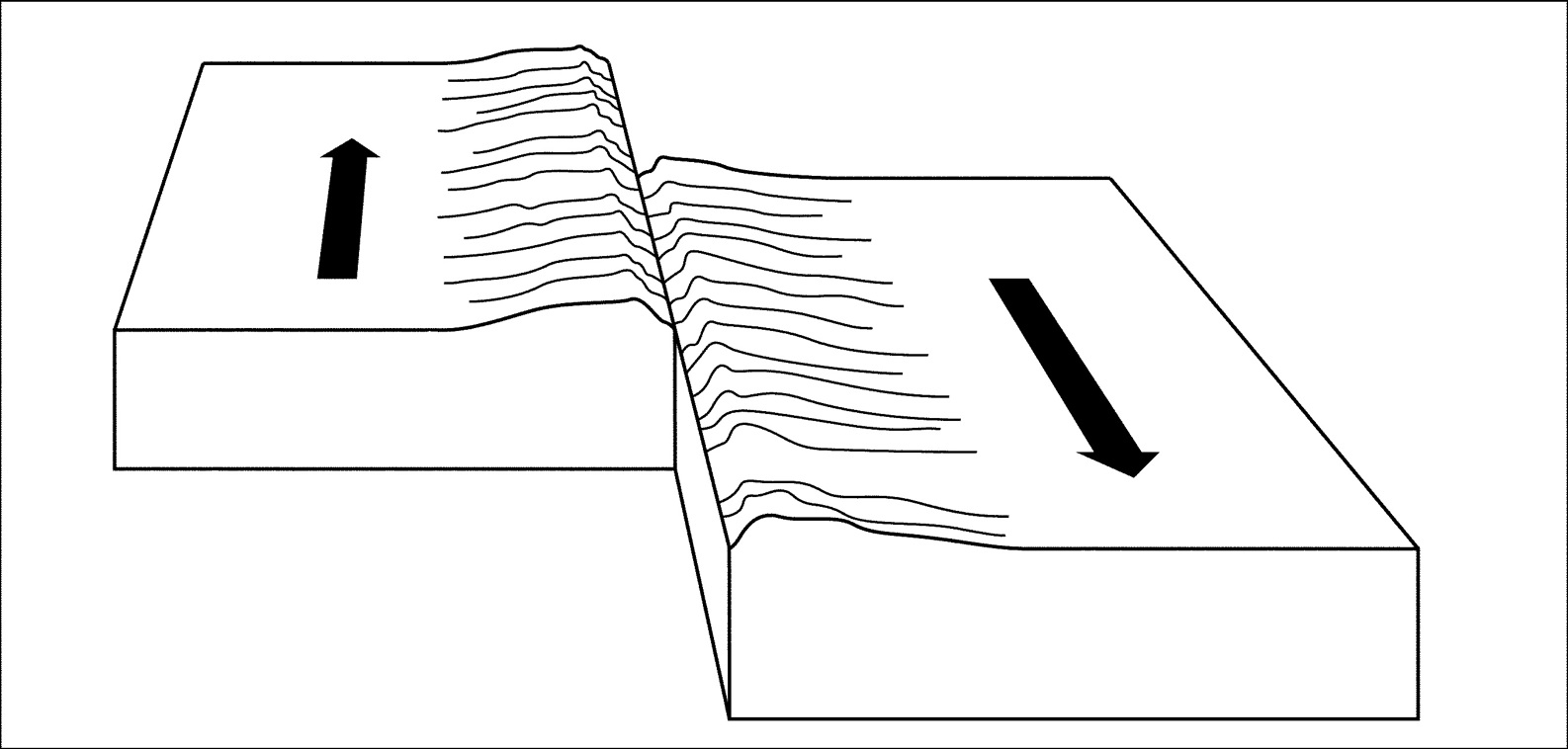
You need to remember that the earth’s crust consists of large, flat plates of rock. They are kilometres thick and drift on the dense, warm mass of magma of the mantle. The movement is
very slow, so it cannot be perceived. The layers of rock that are closer to the mantle are hotter and melt more readily. Nearer the surface of the earth, the layers of rock are cooler and therefore harder.
Where the plates of the earth meet, they collide or slide against one another. Because of the shifting of the layered rock, they may bend or fold and even break like a plank that is broken in two. The earth’s crust is able to withstand the stress and pressure that is built up because of the movement from within. When it reaches a point at which it cannot accommodate the pressure by bending or folding, it cracks and breaks. Then there is a shift in the layers of rock and people perceive it as an earthquake.A fault line occurs which is even visible at the earth’s surface.
An earthquake is felt for a few minutes only, but after-shocks may occur for a while afterwards.
The well-known San Andreas fault runs through San Francisco in the American state of California.
Millions of people live in this area, and are aware of this threat.
Figure 5 shows how the large rock plates move past one another very slowly (5 – 7 cm per year).
When the sides hook onto one another, the stress increases. The rocks suddenly move and start to break off. The result – an earthquake occurs.
Figure 2.1.
Figure 6
The strength of an earthquake is measured by a seismograph
Activity 1:
To build a model of an earthquake
[LO 2.1, 2.3]
Making a model of an earthquake: Work in groups.
1. Obtain two equally thick wooden boards. Place them alongside one another. Use cardboard to make building blocks that can be used to represent bricks, houses or buildings. Place these
blocks in position over the fault line (where the two wooden boards touch one another). Now
draw the boards away from one another or slide them past each other in opposite directions.
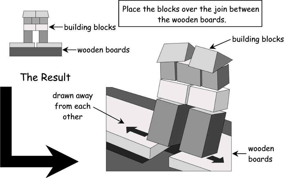
Figure 2.2.
2. Explain what exactly happened to the blocks?
3. What are the names of the different parts of the earth’s crust (represented by the wooden boards)?
4. What would you suggest for making buildings more Earthquake proof? Discuss this in your
group and report your suggestions to the class.
Where do most earthquakes occur?
Earthquakes mainly occur at the margins of ground-plates, which is where these plates are slowly moving towards or away from each other. The movement causes earthquakes to occur in the
countries that lie above the margins of the plates, while countries that lie towards the centres of the plates are not seriously threatened by earthquakes.
South Africa is situated in the centre of a ground-plate; therefore we may not necessarily
experience very serious earthquakes. But the stirrings in the mantle of the earth’s crust are noticeable in South Africa, as we have experienced in 1969 when an earthquake in the Boland
caused much damage in Ceres.
In the next learning unit the map will show that earthquakes and volcanoes occur at the same place s.
(See figure 8)
Activity 2:
To indicate on a map of the world in which areas earthquakes occur
[LO 2.1, 2.2]
2. The effect (consequences) of earthquakes on the lives of people and socio-economic activities Read the magazine article that follows.
You are simply strolling down the street in the city or town where you live. Suddenly the ground around you starts to buckle and form waves like those that form in a dam into which a stone is hurled.
An awful droning, almost like a lamentation, rises from the earth. Around you buildings collapse like houses built of cards and the street in front of you is bursting open as if made of strips of soft, torn cardboard.
Railway girders bend and tear, bridges collapse, dam walls break. People and cars tumble into the enormous gaping cracks in the earth. The cracks close up again and everything disappears forever.
Everywhere bricks, concrete blocks, beams and pillars fall down on people who scramble left and right for a place of shelter that cannot be found.
Fires break out because electric cables and gas pipes are broken. Water rushes from burst pipes.
Windowpanes lie shivered into razor-sharp splinters among the rubble, adding to the horror. A most dreadful natural disaster. Horror as humankind has known it since the earliest times.
Earthquake!
Huisgenoot, Jongspan, 21 May 1987.
Such an earthquake is rated as a very serious disaster, but all earthquakes fortunately are not equally severe. There may be a tremor of the earth’s crust every thirty minutes, but only about 500
of them are actually felt in any year. Fortunately those that do great damage and claim thousands of lives are few and far between.
Trace the world map from figure 8 and indicate only the areas where earthquakes occur. Then
colour it in red.
Activity 3:
To discuss the consequences of earthquakes
[LO 2.1, 2.2]
1. Read the magazine article attentively. Form groups for discussing the effects of earthquakes on: a) People
b) Nature
2. Collect photographs, pictures and newspapers or magazine cuttings dealing with earthquakes.
Bring it along to the class for a discussion session and use it to supplement the information in your notes.
3. Read the following paragraph dealing with Tsunamis and try to find pictures and additional information dealing with this natural phenomenon.
Tsunami – another result of earthquakes!
When rock on the ocean floor shifts unexpectedly, the overlying seawater is also affected and a gulf that can move at 800 km per hour develops. When the gulf reaches the shallower bays of
coastal areas it is dammed up higher. It can reach heights of between 30 and 60 metres and can cause serious destruction by flooding and destroying harbours and towns along the coast.
3. Why some people are at a higher risk to be affected by tropical cyclones than others
If you look at the map of the world (figure 8 on p. 33) on which the ground-plates are indicated, you will notice that we find some of the world’s most densely populated areas in these danger zones. Should an earthquake occur, many lives could be lost.
In developed countries or regions like Europe, the USA and Japan an earthquake’s damage can be limited and losses minimised. Buildings, bridges and roads are built to resist the effect of earthquakes. The infrastructure in such countries are highly sophisticated and their health care and medical services are immediately available in case of emergencies.
It is different, though, in developing countries. Many people die and constructions are easily destroyed. Buildings are usually erected in the cheapest possible way and cannot withstand the force of an earthquake. Thousands are left homeless, hungry and injured. The poor infrastructure prevents that aid reaches them soon enough. Corpses start decaying and drinking water is polluted, spreading disease which increases the number of deaths.
Activity 4:
To discuss the reason why people live in areas where earthquakes occur
[LO 2.2]
1. Why do people decide to live in areas where earthquakes occur? Take some time to think about this and then give your own opinion.
2. Where would you hide if an earthquake struck in your environment?
4. Precautionary measures: managing risk and reducing risk
Can earthquakes be forecast?
Unfortunately, this is not always possible. However, the earth’s crust is intensively studied and sensitive instruments register the slightest movement in the crust.
Scientists use special methods and apparatus, e.g. seismographs, to study and forecast
earthquakes. A seismograph can detect any movement in the earth’s crust. When foreshocks occur scientists are able to detect activity in the earth’s crust and issue warnings in time. Some satellites are also equipped to pick up movement in the earth’s crust.
There are also other non-scientific signs in nature that, if observed in time, could help to forecast an earthquake, e.g.
a sudden significant change in the level of groundwater (e.g. in wells);
the sudden strange behaviour of animals.
If earthquakes could be forecast in time, warnings to evacuate the danger zones could be issued and so loss of life could be limited. Whether all people listen to such warnings is an open
question.
Remember – not all earthquakes can be forecast. Some happen suddenly, without any foreshocks or other signs.
Activity 5:
To list emergency measures in case of an earthquake
[LO 2.3]
Imagine that you live in an area where earthquakes occur frequently (where there is a weak place in the earth’s crust). Draw up a list of emergency measures that should be applied before, during and after an earthquake.
Copy the world map from Figure 8 and indicate the areas where earthquakes occur on your own
map. Then use red to colour in these areas.
Assessment
Table 2.1.
Learning Outcomes(LOs)
LO 2
GEOGRAPHICAL KNOWLEDGE AND UNDERSTANDINGThe learner will be able to
demonstrate geographical and environmental knowledge and understanding.
Assessment standards(ASe)
We know this when the learner:
2.1 describes and explains how natural hazards such as volcanoes, earthquakes and flooding
occur, and their impact on human lives and socio-economic activities [people and places];2.2
investigates and explains why some people face a higher risk than others with respect to natural hazards [people and resources];2.3 identifies how risks and hazards can be managed [people and the environment].
Memorandum
Activity 1:
1. Constructing a model
The teacher must provide two wooden planks of equal thickness and 7 - 9 building blocks made from cardboard. Follow the instructions as set out in Learning Unit 4, page 5, to carry out the experiment.
1. As the planks are drawn away from each other in opposite directions, the building blocks also start shifting. If the planks continue to move, the building blocks tumble down.
2. The two wooden planks represent two different layers constituting the earth’s crust. See Figure 8.
3. See cutting on earthquakes and the design of buildings and insert here to serve as memo.
Learners may also give their opinions. **(See accompanying note for an answer.)
Activity 2:
Ask learners to trace the world map, using Figure 8. The teacher can also supply the learners with a world map (outline only). Learners indicate in red where earthquake areas are to be found on our planet.
Activity 3:
Many people die or are seriously injured;
Damages amounting to millions of rands occur;
Buildings collapse or severe damage is caused;
Tarred roads buckle and are ripped apart;
Bridges collapse;
Dam walls collapse or get damaged;
Fires break out because of electric cables and gas pipes that get amaged;
Power failures cause total blackouts;
Water streams from burst pipes and cause flooding and a shortage of fresh water;
Sewage pipes break and cause pollution, which cause health hazards;
Telephone connections are severed;
Mountain passes are blocked due to rock falls;
The country’s economy is severely affected. International aid is important for reconstruction.
1. b) Nature:
River courses change as a result of shifts in the earth’s crust. Consequently the natural
environment also changes;
Topsoil along the mountain slopes become undone and start sliding down the slopes. Human
beings and buildings might be buried under the landslides;
The natural vegetation is therefore destroyed and it may take many years to recover. In the
meantime the lack of vegetation on the bare slopes increases the chances of soil erosion.
Floods and destruction occur in low-lying areas if an earthquake has originated under the sea-bed, causing a tsunami.
1. Learners bring photographs, pictures and newspaper cuttings on earthquakes to the classroom.
They discuss these, adding some of the points to their notes.
3. Tsunami’s The Southern Asian tsunami of 26 December 2004.
Learners collect information on this.
See web page http://iri.Ideo.columbia.edu-lareef/tsunami
Activity 4:
1. Why do people live in these regions?
Earthquakes are not an everyday phenomenon. Some regions might experience an earthquake once in a lifetime. People therefore take a chance and hope that it will not occur again.
Many of the “endangered regions” are also important financial and industrial centres. There are many job opportunities and prosperity there. Financial implications are therefore important
considerations.
Traditionally many generations have been living there (especially in developed countries) who do not move away easily.
2. What to do during an earthquake.
Advice is plentiful.
Leave the building immediately.
Move to the top storey immediately if you live in a high rise building so that the building does not collapse on you.
Avoid the lifts of tall buildings. You could be trapped in them.
Seek refuge under a concrete beam if available, otherwise under stealthy furniture such as tables.
Move to open fields immediately where there are no flying objects.
Activity 5:
1. Emergency measures before an earthquake
Listen to the radio or TV daily. If tremors in the crust of the earth are picked up, warnings will be transmitted immediately.
Always have a backpack ready containing fresh clothes, a blanket or warm clothing.
The following should also be included: a) fresh water
b) non-perishable foodstuffs
c) medicine
d) a flashlight
Always keep your personal documents ready.
2. Emergency measures during an earthquake.
Find a place of safety immediately or move to an open field.
3. Emergency measures after an earthquake.
Avoid snooping around in damaged buildings. Loose objects could fall and cause injuries.
Erect tent settlements for homeless people as temporary housing facilities until emergency
personnel have completed their clearing up operations.
Erect temporary sewage and water supply points.
Erect temporary catering facilities.
Supply medical aid to people who have been injured.
2.2. Volcanoes*
SOCIAL SCIENCES: Geography
Grade 7
NATURAL HAZARDS
Module 5
Volcanoes
1. The occurrence and causes of volcanoes
Molten rock below the earth’s crust is called magma. When it flows to the surface it is called lava.
Why lava flows to the surface is not clear enough for people to agree on the reasons for eruptions
and no one has been able to investigate the heart of the earth to find out what happens there.
We do know, however, that the weight of the solid crust of the earth is so great that the fluid rock is forced upwards at weak places in the earth’s crust. This molten rock is extremely hot, with temperatures of between 800 and 1 500 C.
If you shake a can of cooldrink, the gas will propel the cooldrink out of the can with great force when you open the can. This is what happens in the case of volcanoes – the molten rock erupts through weak places in the earth’s crust and lava, rocks and ash are propelled into the air.
Then the lava cools down and solidifies to form new rocks known as igneous rock.
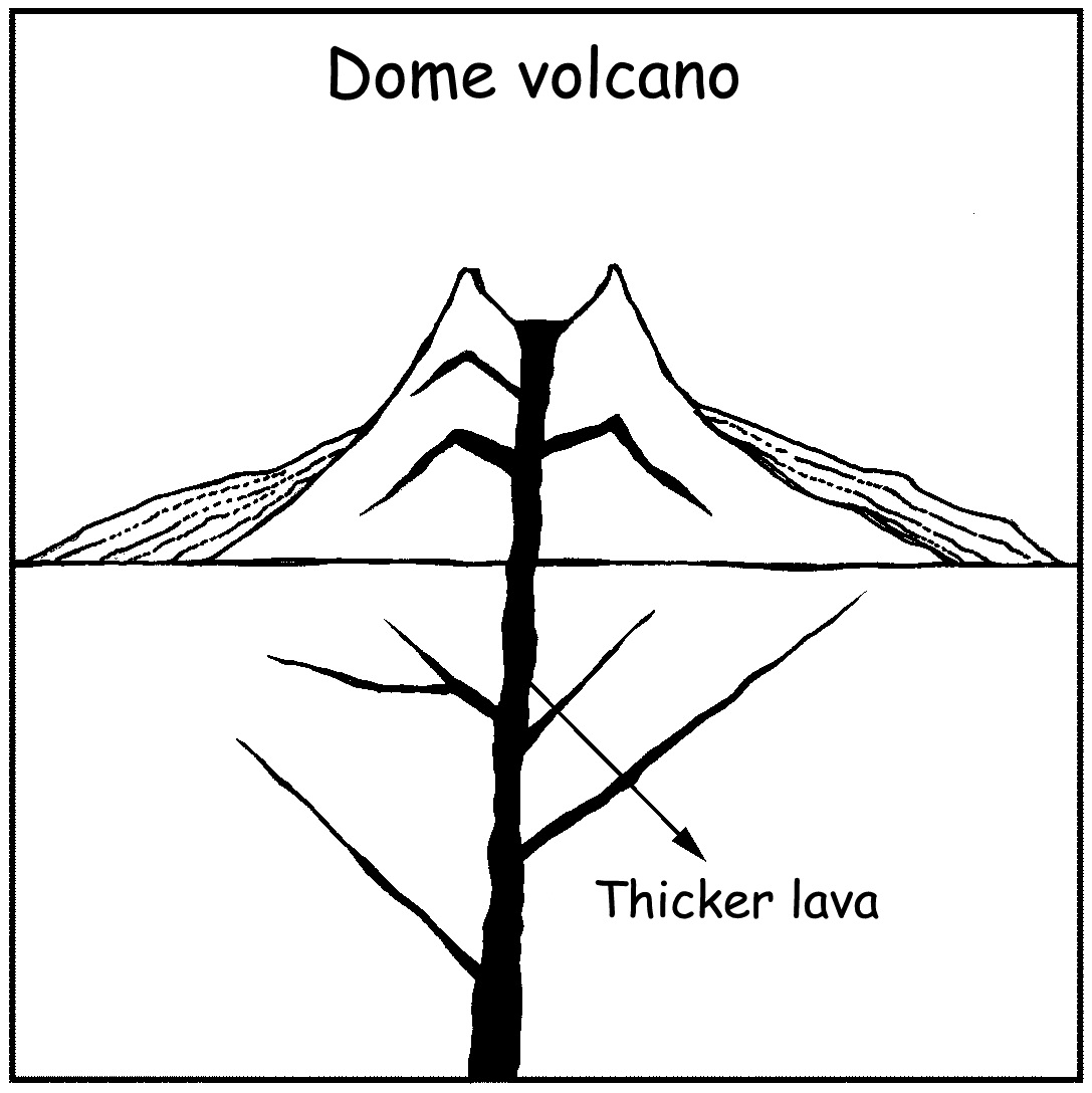
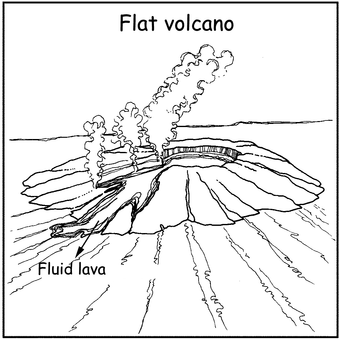
Some volcanoes produce very fluid lava that flows over a large area before solidifying. Thin plates of igneous rock are formed in this case. Other volcanoes build up domes because the lava is less fluid and does not flow far from the core.
A very forceful explosion can force out the whole of the dome and cause a large open hole called a caldera, or crater. There are roughly 450 active volcanoes worldwide. Fortunately, they do not erupt continuously and are therefore referred to as dormant volcanoes.
Figure 2.3.
Figure 2.4.
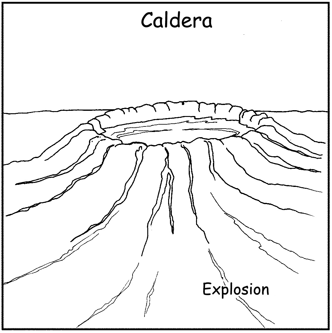
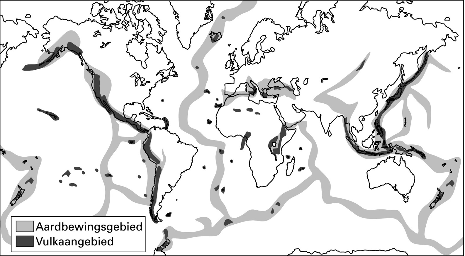
Figure 2.5.
Where do most volcanoes occur?
Study figure 4.
There are about 5 000 volcanoes. They only occur in particular places. These places are situated above the margins of the large plates of the earth’s crust. The movement of these plates lead to volcanic eruptions and earthquakes.
Figure 2.6.
Quake areasVolcanic areas
Figure 4
The distribution of the main volcanic and earthquake areas of the earth
Which volcanoes have caused the greatest destruction?
The most destructive volcano of all time was Krakatoa, in Indonesia. When it erupted in 1883, more than 36 000 people died. The bang of the explosion was heard 5 000 km away and the
pollution that resulted from the eruption was visible in copper-coloured sunsets across the earth for years.
Another well-known example of the destructive force of a volcano comes from the eruption of
Mount Vesuvius, which buried the city of Pompeii in the Bay of Naples under volcanic rocks and ashes in 79 AD.
2. The effect (consequences) of volcanoes on people’s lives and their socio-economic activities Thousands of lights glitter in the dark dome of the night. From a distance the explosions that hurtle glowing rocks and streams of fire into the night look like an expansive display of fireworks.
Rocks and ashes flung up high pollute the air.
A river of red, smoking lava slithers over the edge of the crater – the warm blood of the living earth, as someone has strikingly described it.
It may flow through fertile valleys for kilometres, devouring every blade of grass, even trees, along its way. Houses crumble and cities are buried under the glowing, driven mass. People who have survived, scramble down the mountainside; warm ash raining down on them. Suffocating
sulphurous gases and a rain of ashes smother other people to death.
Somewhere else on the earth, in the middle of the desolate open sea, a volcano forces its way to find its place in the sun and a new island is born. Tsunamis develop and they flood and destroy the low-lying land of bays and islands.
Death and birth. Below the drifting crust of our struggling planet lies a stirring world of molten rock. In the process that has continued through the ages, it may erupt to destroy what lies above, but also, surprisingly, to create.
[ Huisgenoot se Jongspan, 4 June 1987 ]
We have seen that volcanoes can also have positive effects. Solidifying lava forms igneous rock, in which precious stones like diamonds are created. Where this occurs, financial welfare follows.
Fertile soils are created when these rocks that originate from lava are eroded over millions of years and such soils nurture crops. In this way, the world is provided with food.
Hot water springs occur near volcanoes. These warm springs naturally become tourist attractions.
In cold countries such warm water is even used to supply buildings with hot water and to heat them.
Activity 2:
To discuss the consequences of volcanoes on people and their environment
[LO 2.1, 2.2]
1. Discuss the article that is printed above in your groups once you have read it, to explain the effect of volcanoes on:
a) People
b) The environment
2. Collect pictures, photos and newspaper cuttings dealing with volcanoes. Bring them to class for discussion. Use the material you have collected to supplement your notes.
3. Why some people are at a higher risk to be affected by volcanoes than others
Disasters happen anywhere, but looking at figure 8 discloses that volcanoes occur more often in certain areas.
People knowingly settle in the vicinity of a volcano. Sometimes such an area is densely populated, as people regard work opportunities and prosperity as more important than a potential volcanic eruption.
As in the case of earthquakes, developed areas can handle the impact of a volcanic eruption with much more ease and efficiency. Warnings can