Geography Grade 6 by Siyavula Uploader - HTML preview
Download the book in PDF, ePub, Kindle for a complete version.
Geography Grade 6
By: Siyavula Uploader
Online: < http://cnx.org/content/col11015/1.1> This selection and arrangement of content as a collection is copyrighted by Siyavula Uploader.
It is licensed under the Creative Commons Attribution License: http://creativecommons.org/licenses/by/3.0/
Collection structure revised: 2009/09/09
For copyright and attribution information for the modules contained in this collection, see the " Attributions" section at the end of the collection.
Geography Grade 6
Table of Contents
1.2. The use of lines of longitude and latitude
1.3. Trade and transport routes
To indicate the most important air-routes
To indicate information on a map of South Africa
To make a decision on the transportation of goods
POPULATION DISTRIBUTION AND DENSITY
There are approximately 6 milliard (6 000 million) people on earth and they inhabit
only approximately 15% of the surface of the earth (see circle graph).
To study a map of the world as a group to acquire information
To have a class discussion on urbanization in SA
To identify urban areas in Western Europe
To reflect on the depopulation of rural areas and urbanisation
POPULATION DISTRIBUTION AND DENSITY ON A GLOBAL SCALE
To do research on Rio de Janeiro and consult a number of sources
To investigate and think about the circumstances of the people of Rio de Janeiro
To discuss the influence of the climate of Rio de Janeiro
To discuss the following two problems
To suggest solutions to problems on poverty
3.1. Weather predictions and synoptic weather charts
3.2. Climate and vegetation regions of the world
CLIMATE AND VEGETATION REGIONS OF THE WORLD
The climate and vegetation regions of the world
To find information in an atlas
CLIMATE AND VEGETATION REGIONS OF THE WORLD
The main biomes (Vegetation regions)
To discuss the effect of dense populations on natural forests
To depict a forest biome by means of collage
To design a poster of a savannah landscape
To do research on desert expansion and write a report about it
To do research on Antarctica and describe the climatic conditions of the ice deserts
To provide possible reasons for poverty/wealth
Just as there are rich and poor people, there are rich and poor countries. There are
obvious reasons for the wealth and the poverty of various countries.
To identify rich and poor countries
4.2. Reasons for wealth/poverty
To discuss the possible consequences of high medical and educational
To investigate access to rain water as a resource
6.Population growth as part of Africa’s problem
To identify the reasons ffor the phenomenon of rich and poor
To express an opinion on the prosperity of the average South African
4.3. Characteristics of developing countries
CHARACTERISTICS OF DEVELOPING COUNTRIES
To do research and record findings
To deal with the problem of poverty in my environment
4.4. HIV/Aids as a developmental problem
To make deductions from sources
To do research about the successful effects of antiretroviral drugs
Chapter 1. Term 1
1.1. Determining direction*
SOCIAL SCIENCES: Geography
Grade 6
MAP WORK AND PRACTICAL WORK
Module 1
DETERMINING DIRECTION
1. Using lines of longitude and latitude to indicate location
In the same way as we draw lines on a map or plan, imaginary lines are drawn on the earth.
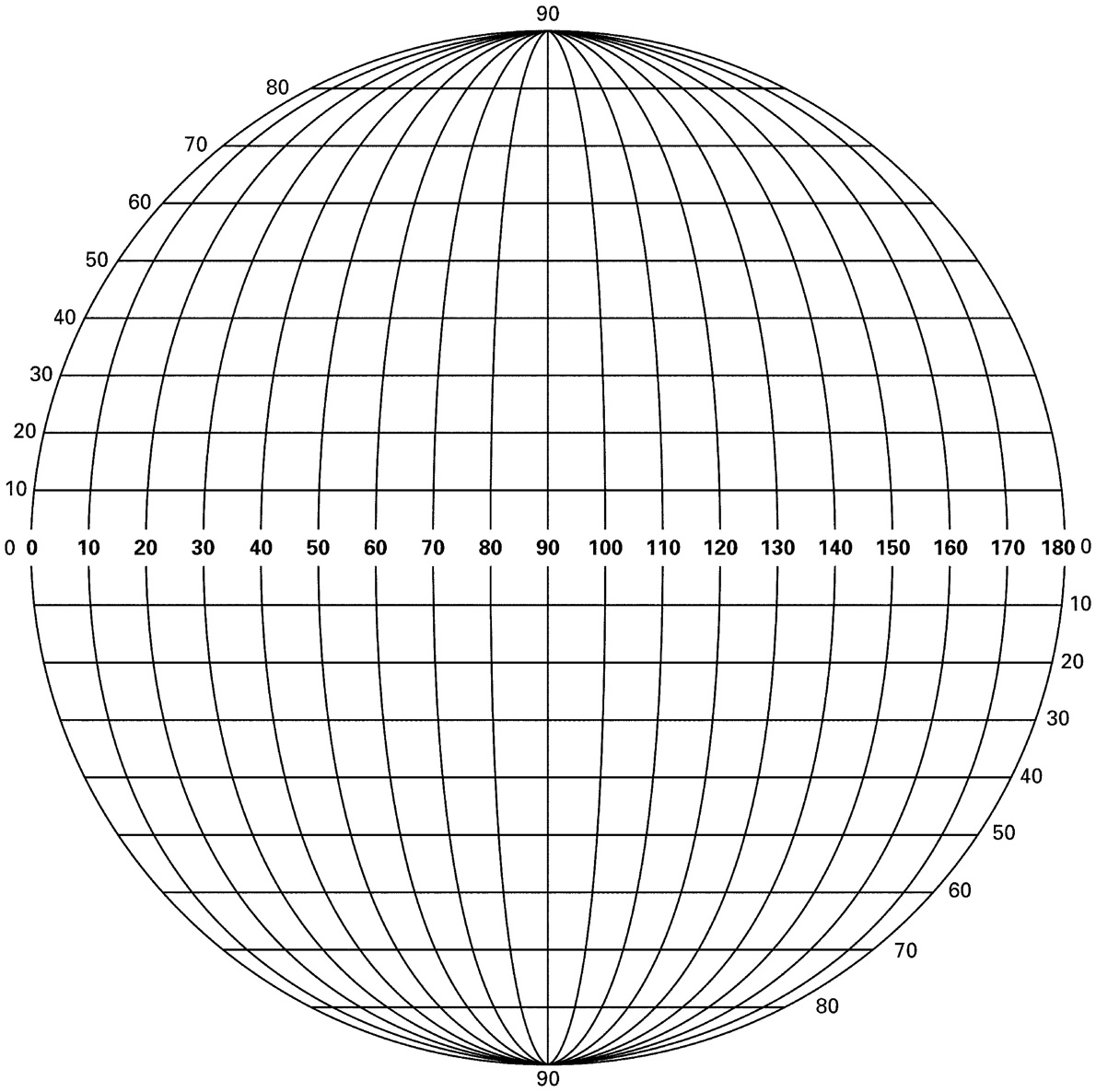
Exactly halfway between the north and south poles, we find the EQUATOR. The equator is called the 0° line of latitude, and runs from east to west. Parallel to the 0° line of latitude, we also find a 90°N and a 90°S line of latitude at the two poles.
The equator divides the globe into two halves. The upper half is called the NORTHERN
HEMISPHERE and the lower one the SOUTHERN HEMISPHERE.
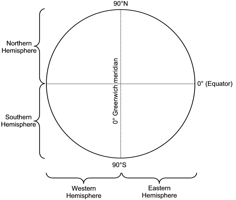
Figure 1.1.
There are also imaginary lines running from north to south. They are called the lines of longitude.
The line of longitude lying on 0° is called the GREENWICH line of longitude. It, in turn, divides the earth into a WESTERN HEMISPHERE and an EASTERN HEMISPHERE. East of the
Greenwich line of longitude run 180 lines of longitude, and to the west of it there are also 180
lines of longitude.
All these lines of longitude and latitude form intersections on the earth, with which the exact location of a place can be indicated. More about this later. For now it is enough if you are able to indicate in which hemisphere(s) a place, land or continent is.
Activity 1:
To answer questions
[LO 1.3, 1.5]
Study a map of the world in your atlas and answer the following questions:
Name the continents through which the equator runs.
The equator runs through three oceans. Name them.
Is Cape Town situated in the Eastern or Western Hemisphere?
Which continents lie completely north of the equator?
Which continent lies completely in the Western Hemisphere?
In which two hemispheres is South Africa located?
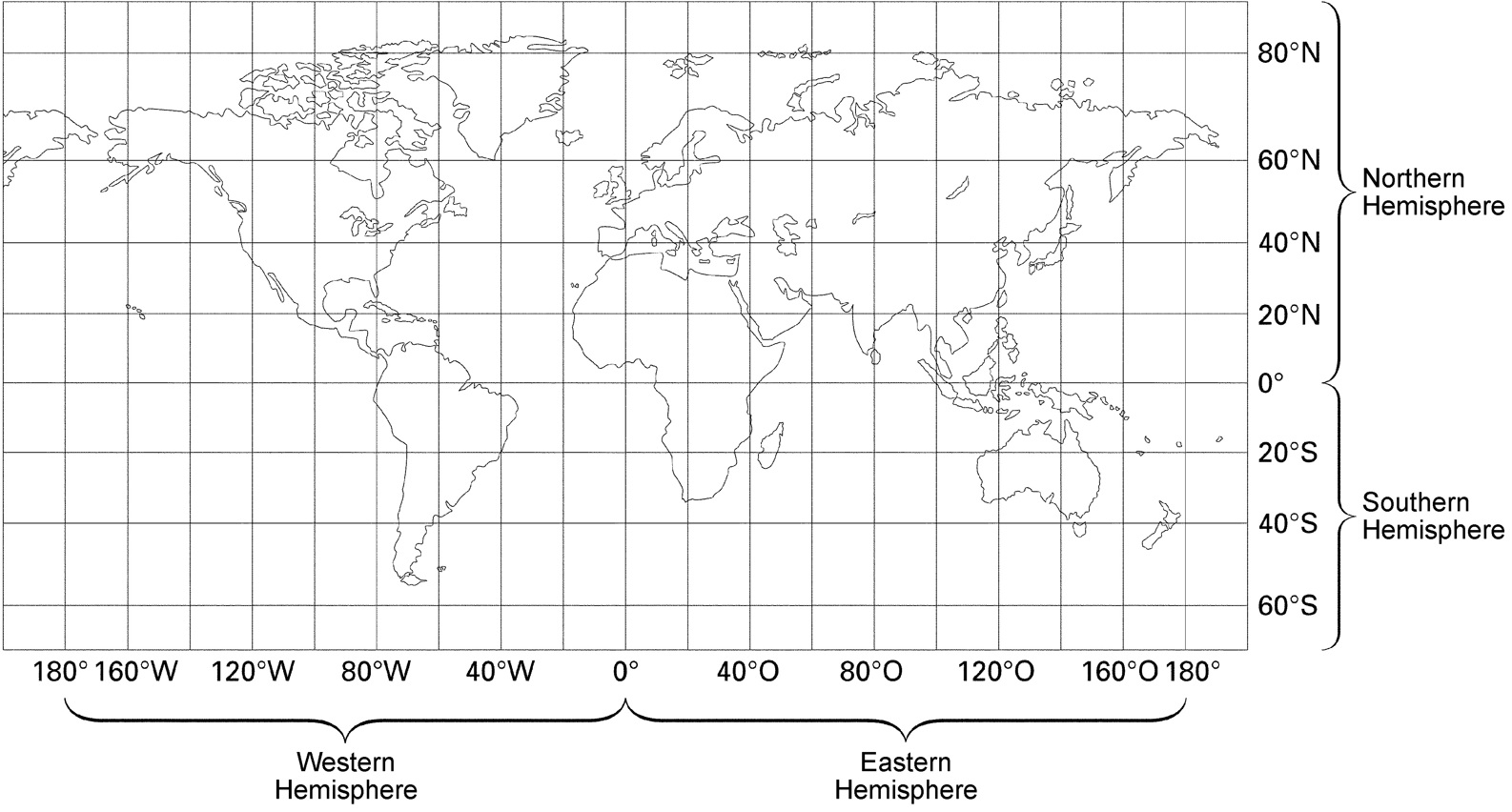
2. Location by means of degrees of longitude and latitude
Lines of longitude and latitude
180 ° 160 °W 120°W 80°W 40°W 0° 40°E 80°E 120°E 160°E 180°
Figure 1.2.
3. Lines of latitude
A few important facts:
The best-known one is the equator (0° line of latitude).
The tropics are at 23½°.
The pole circles are at 66½°.
The poles are at 90° (actually a point and not a line).
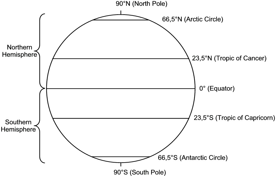
All lines of latitude run parallel to one another.
Lines of latitude indicate the northern and southern hemispheres.
When the location of a place is indicated, latitude is mentioned first.
The latitude of a place is a good indication of its climate. You know that places near the equator (0°) are normally very hot. You also know that places near the poles (90°) are very cold.
Remember that there are more factors than only latitude that influence climate.
The most important lines of latitude
Figure 1.3.
4. Lines of longitude
A few important facts:
The best known is the Greenwich meridian (0° line of longitude).
From Greenwich (0°) the lines of longitude are numbered to the east up to 180°.
This forms the Eastern Hemisphere.
From Greenwich (0°) the lines of longitude are also numbered to the west up to 180°.
This forms the Western Hemisphere.
Lines of longitude meet at the poles and are all the same length.
At the equator the lines of longitude are furthest from each other.
When the location of a place is indicated, the longitude is always mentioned second.
Eastern Hemisphere
Figure 1.4.
Western Hemisphere
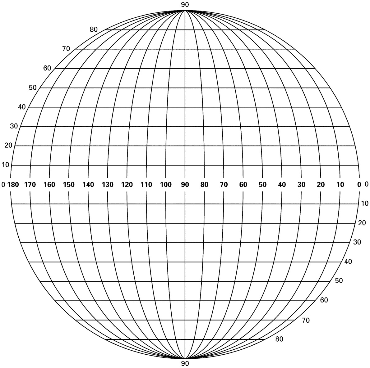
Figure 1.5.
Use a globe or a map in your atlas and make sure you understand what each of these facts means.
The Greenwich meridian (0° line of longitude) forms a half-circle on a globe. If it is continued around the back of the globe, it forms another half-circle. The half-circle at the back is called the antipode of the 0° line of longitude and its number is 180°. A line of longitude and its antipode always form a full circle. Therefore, from the 0° line of longitude, one can move 180°
to the west and 180° to the east.
In this way, each line of longitude has an antipode and if the numbers of the two lines’ grades are added together, the answer is always 180°.
But now we have a problem: If we move eastward from the 0° line of longitude and westward from the 0° line of longitude, we reach the 180° line of longitude from both sides. Now our times are going to differ a lot!
To solve this problem, the International Date Line (IDL) was developed.
It follows the 180° line of longitude, but never cuts across land.
The date east of the IDL is one day earlier;west of the IDL is one day later.
From east to west, you lose a day if you move across the IDL.From west to east, you win a day if you cross the IDL.
A place’s longitude is also an indication of time.
The earth revolves from west to east around its own imaginary axis. So the sun rises earlier in places that are nearer to the east.
The sun rises in Durban (31°E) approximately 50 minutes earlier than in Cape Town (18½° E). In South Africa such a difference isn’t a problem, because we use only one time zone (30° E). In a country like the USA, however, it becomes a problem. The sun rises in New York (74°W)
approximately three hours earlier than in San Francisco (122½°W). So in the USA you need to have different time zones.
You may have noticed that when rugby matches are played in Australia or New Zealand and we watch them on TV, it’s very early in the morning over here. This is the case because those countries lie very far east of South Africa and so the sun rises “earlier” over there.
Calculating the time difference isn’t so difficult. It all has to do with the way in which the earth revolves around its own axis.
How long does it take for the earth to revolve around its own axis?It takes 24 hours.
Through how many degrees does the earth revolve in these 24 hours? The earth revolves
through 360°.
If we now divide the 360° by 24 hours, we find that the earth revolves through an angle of 15°
every hour. If two places are 15 degrees of longitude from one another, the sun will rise precisely one hour earlier at the one lying further east.
Assessment
Table 1.1.
Learning Outcomes(LOs)
LO 1
GEOGRAPHICAL ENQUIRYThe learner will be able to use enquiry skills to investigate
geographical and environmental concepts and processes.
Assessment standards(AS’s)
We know this when the learner:
selects and records relevant information from sources for specific purposes (including
recording and observing in the field);
locates relevant places on maps using latitude and longitude (degrees and minutes);
uses information to propose solutions to problems;
1.5 reports on enquiries, through discussion, debate, structured writing, graphs, tables, maps and diagrams.
1.2. The use of lines of longitude and latitude*
SOCIAL SCIENCES: Geography
Grade 6
MAP WORK AND PRACTICAL WORK
Module 2
THE USE OF LINES OF LONGITUDE AND LATITUDE
1. How are lines of longitude and latitude used in your atlas?
Lines of latitude (N or S) and longitude (E or W) can also be used TOGETHER to describe the location of places exactly. Then they are called that place’s location co-ordinates.
Let’s say you have no idea where Sydney is on the globe. Rather than reading and searching a map for hours, you can go to the INDEX at the back of the atlas, where the names of places are arranged alphabetically.
Example:
Next to Sydney the following particulars are given:
Sydney 55 33.55 S 150.30 E
This means
55 - page 55 in the atlas (differs from atlas to atlas)
33.55 S - 33 degrees and 55 minutes south
150.30 E - 150 degrees and 30 minutes east
By using the degree reference, any place can be easily found. The degree reference refers to degrees of longitude and latitude.
Activity 1:
To determine the location of capital cities
[LO 1.3]
Find the following capitals in the index of your atlas, and write down the location of each one completely. Then indicate which one should have the coldest climate, which ones should have roughly the same climate, etc.
Table 1.2.
Capitals
Location
Climate
Stockholm 59.20 N 18.10 E
Berlin
Rome
Tripoli
Kinshasa
Windhoek
Cape Town
[LO 1.2]
Name the three kinds of scales indicated on the map of the world:
Measure the distance between the following places in centimetres. Use the map’s ratio scale and determine the real distance in kilometres. Show your calculations.
a) (4) Cape Town to (5) Melbourne _______________km
b) (6) New York to (7) London ______________________km
c) (8) Paris to (9) Johannesburg_________________km
Study the world map and say in which direction the following countries lie from one another: South America to Europe
Europe to Africa
Australia to South Africa
Europe to Australia
If you want to fly from (9) Johannesburg to the nearest ocean, in which direction and how far will this be in kilometres?
Direction
Distance_______ km
In which two hemispheres are the following countries and continents situated?
h) Asia___________and_______________
i) Canada ___________and_________________
j) South Africa ____________ and_____________
k) India _______________and______________
l) USA _____________ and__________________
Which lines of latitude are represented by numbers (10), (11) and (12)?
Name the line of longitude that runs through London.
In the morning, will the sun “appear” at Australia or South Africa first? Give reasons for your answer.
Figure 4
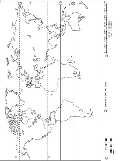
Figure 1.6.
Activity 3:
To use an atlas index
[LO 1.3]
Find the place names in the following questions in your atlas index and answer each of the questions:
1. Which river flows through Munich?
2. Which channel connects Berlin with the North Sea?
3. Name the largest island in Japan
4. How high is the highest point of the Caucasus?
5. Name the capital of Taiwan
6. Between which two parts of the United Kingdom are the Cheviot Hills?
_________________ and_____________________
7. What is the time difference between Rosario and Manaus in South Africa?
8. Which city lies 25 km southeast of Amsterdam?
9. In which country can we find the city of Stuttgart?
10. Which river runs into Lake St Lucia?
11. How far is the Argentine capital from the capital of Uruguay?
12. What is so unique about Lake Titicaca? (Look at the colour of the surrounding area.)
13. Which of Ladismith or Ladysmith is closest to Cape Town?
14. On which island can you find the city of Palermo?
15. Roughly how many kilometres is the coastline of the Nigerian delta?
Assessment
Table 1.3.
Learning Outcomes(LOs)
LO 1
GEOGRAPHICAL ENQUIRYThe learner will be able to use enquiry skills to investigate
geographical and environmental concepts and processes.